Final draft scoping report
ENVIRONMENTAL IMPACT ASSESSMENT FOR
THE KUSIBED DELTA AND DUNE BELT AREA
STRY OF ENVIRONM
ENT AND TOURISM,
DIRECTORATE OF ENVIRONMENTAL AFFAIRS
NAMIBIAN
MANAGEMENT (NACOMA)
Final Draft Scoping Report
UNIVERRSITY OF NAMIBIA CENTRAL
CONSULTANCY BUREAU (UCCB)- 2011
Content List
List of Abbreviations
MGs – Matching Grants
EIA – Environmental Impact Assessment
SEA - Strategic Environmental Assessment
EMP - Environmental Management Plan
KDDP/T – Kuiseb Delta Development Project/Trust
PCO – NACOMA Project Coordinating Office
TOR – Terms of Reference
MET – Ministry of Environment and Tourism
DEA – Directorate of Environmental Affairs
CBNRM – Community-Based Natural Resources Management
NATMIRC – National Marine Information and Research Centre
ICZM – Integrated Coastal Zone Management
ORV – Off-Road Vehicles
NPC – National Planning Commission
DST – Decision Support Tool
Kuiseb Delta & Dune Belt EIA Team:
Dr Sindila Mwiya (EIA & EMP expert, DST and GIS expert):Risk-Based Solutions
Dr John Kinahan (Archaeology Study): Quaternary Research Services
Mr Peter Cunningham (Biophysical Assessment): Environment and Wildlife Consulting
Ms Margaret Angula (Socio-economic and Environmental Governance): UCCB –
University of Namibia Central Consultancy Bureau
Ms Johanna Niipele (Geomorphology & GIS): UCCB – University of Namibia Central
Consultancy Bureau
Dr Martin Hipondoka (Geomorphology & GIS): UCCB – University of Namibia Central
Consultancy Bureau
Executive Summary
1.1 Introduction
The NACOMA project under component 3 supports the management planning of coastal
biodiversity hotspots, more specifically the "Implementation of Priority Actions under the
Management Plans at site and landscape level" under sub-component 3.2. This supports
small Matching Grants (MGs) for targeted investments in specific Project intervention
sites in ecosystems of biodiversity importance. Furthermore, the NACOMA project
commissioned the undertaking of the Strategic Environmental Assessment of the
northern regions of Kunene and Erongo in 2006. The SEA strongly recommended that an
Environmental Assessment be conducted for the Dune belt area between Swakopmund
and Walvis Bay. It is against this background that NACOMA commissioned this study to
conduct an environmental impact assessment (EIA) study and develop an environmental
management plan (EMP) in reconfirming the carrying capacity of the Kuiseb Delta to
community based tourism and Dune Belt Area to various conflicting resource use
1.2 Project Location
The study area lies in the Central Namib Desert, between the Swoop River in the North
and the sand dune area south of the Kuiseb River. The Kuiseb Delta lies in an area
where the Kuiseb River flows down a steepened gradient onto the coastal flats. The Dune
Belt Area between Swakopmund and Walvis Bay is important for tourism as it creates a
number of job opportunities as part of the socio-economic development for the two
1.3 Environmental Assessment Requirements
The SEA for the Erongo Region strongly recommended an EIA be conducted in the Dune
Belt area between Walvis Bay and Swakopmund. This area is spawned by tourism and
recreational activities. The extent of impacts resulting from tourism activities is not
assessed in-depth during SEA study. Hence, it makes sense to conduct an EIA for the
entire area as recommended although the purpose of this project was initiated for the two
MGs (KDDT and Walvis Bay Bird Paradise cc).
Environmental Regulatory Framework
Important legislative instruments that affect the feasibility, operation and management of
eco-tourism activities include:
Cabinet approved Environmental Assessment Policy for Sustainable
Development and Environmental Conservation of 1995 published by the Ministry of Environment and Tourism (Directorate of Environmental Affairs (DEA), 1995;
Environmental Management Act, 2007, (Act No. 7 of 2007) - (Not yet
Water Resources Management Act, 2004, (Act No. 24 of 2004) - (Not yet
The Nature Conservation Ordinance, Ordinance 4 of 1975, Amendment Act,
Act 5 of 1996 and the draft Parks and Wildlife Management Bill of 2006;
National Waste Management Policy, 2010 National Heritage Act, 2004 (Act No. 27 of 2004) Coastal Policy for Namibia Green Paper
Other legislations, policies and regulations to be identified during the full EIA.
3. Current and Future Land Uses of the Study Area
The study area between Swakopmund and Walvis Bay is concentrated with Tourism and
recreational activities. Coastal tourism is one of the priority economic area for local,
regional and national development. Community-based tourism provides avenue to local
communities in the area (NACOMA, 2007). This area is also subject to intensive
recreational pressure during peak holidays (NACOMA, 2004). There are also other
activities in the area, such as quad-biking, cultural, sightseeing and eco-tours operating in
the study area. The nature of these activities prompted this EIA study commissioned by
Description of the Proposed Project
There are two proposed projects that received Matching Grant funding from NACOMA
PCO. These projects are proposing community-based eco-tourism activities. The Kuiseb
Delta Development Trust applied for a concession from MET and engage in Community
Based Tourism activities. The Walvis Bay Bird Paradise proposes to establish a bird
watching tourism activity. There are also other activities in the area, such as quad-biking,
cultural, sightseeing and eco-tours operating in the study area. The nature of these
activities prompted this EIA study commissioned by NACOMA PCO.
Baseline Environment
This section presents the description of the natural environment that may be affected by
activities proposed in the study area. The Central Namib near the coast has a
temperature range that is moderated by proximity to the sea. The average precipitation
(fog and rain) ranges around 15mm at the coast. The wind at the coastal areas of
Namibia is characterised by strong southerly winds but westerly and south westerly winds
are also frequent. The area is characterised by four distinct geomorphological units. The
largest by far is the dune field. Other units include inter-dune plains, gravel/ coastal plain,
river beds and delta. Sufficient good quality groundwater is available for different land
users in the coastal towns.
The literature review was undertaken to determine the actual as well as potential
vertebrate fauna associated with the general area commonly referred to as the Southern
Namib or Southern Desert. This area is bordered inland by the Central Namib or Central
Desert. Climatically the coastal area is referred to as Cool Desert with a high occurrence
of fog. The Namib Desert Biome makes up a large proportion (32%) of the land area of
Namibia with parks in this biome making up 69% of the protected area network or 29.7%
of the biome. Four of 14 desert vegetation types are adequately protected with up to 94%
representation in the protected area network in Namibia. With the exception of municipal
land, the area falls within the recently proclaimed Dorob National Park. No communal
and freehold conservancies are located in the general area with the closest communal
conservancy being the ≠Gaingu Conservancy in the Spitzkoppe area approximately 100
km to the northeast. Two important coastal wetlands – i.e. Walvis Bay Wetlands and
Sandwich Harbour – both Ramsar sites, occur in the area. According to Curtis and
Barnard (1998) the entire coast and the Walvis Bay lagoon as a coastal wetland, are
viewed as sites with special ecological importance in Namibia. The known distinctive
values along the coastline are its biotic richness (arachnids, birds and lichens) with the
Walvis Bay lagoon‟s importance being its biotic richness and migrant shorebirds as well
as being the most important Ramsar site in Namibia. The Ramsar site covers 12 600 ha
with regular counts of birds varying between 37 000 and well over 100 000 individuals,
albeit mainly migratory species. The Walvis Bay wetland is considered the most
important coastal wetland in southern Africa and one of the top 3 in Africa. The Sandwich
Harbour Ramsar site covers 16 500 ha and falls within the Namib-Naukluft Park and
enjoys full protection. This area is a centre of concentration of migratory shorebirds,
waders and flamingos regularly supporting over 142 000 and 50 000 birds during summer
and winter, respectively. The area is bordered by the Kuiseb River to the south (Walvis
Bay area) and the Swakop River to the north (Swakopmund area) with catchment areas
of 15 500 km² and 30 100 km², respectively. The central coastal region and the Walvis
Bay area in particular, is regarded as "relatively low" in overall (all terrestrial species)
diversity. Overall terrestrial endemism in the area on the other hand is "moderate to
high". The overall diversity and abundance of large herbivorous mammals (big game) is
viewed as "low to medium" with 1-2 species while overall diversity of large carnivorous
mammals (large predators) is determined at 4 species with brown hyena being the most
important with "medium" densities expected in the area. It is estimated that at least 54
reptile, 7 amphibian, 42 mammal and 182 bird species (breeding residents) are known to
or expected to occur in the general/immediate Walvis Bay/Swakopmund area of which a
high proportion are endemics.
6. Scoping Study Conclusions
Coastal tourism is a priority economic area for local, regional and national development.
Community-based tourism activities can provide employment but they are also likely to
cause social and environmental impact. Biological hotspots, breeding areas,
environmental sensitive areas may suffer from uncontrolled tourism development and
activities. These impacts however can be effectively mitigated through careful planning
and design of sustainable tourism activities.
Scoping Study Recommendations
Full Environmental Assessment
Based on the findings of the scoping study it is recommended that a full EIA and the
development of an EMP be undertaken for the proposed eco-tourism and recreational
activities in the Kuiseb Delta and Dune Belt area. Draft TOR for the full EIA and EMP
include the list of stakeholders, specialist studies to be undertaken, likely positive and
negative impacts to be considered as well as draft proposed outline of the EIA and EMP
Aims and Objectives of the Full Environmental Assessment (EA)
The aims and objectives of the full EIA and EMP with respect to the proposed eco-
tourism activities in the Kuiseb and Dune Belt areas are:
To assess all likely positive and negative impacts environmental and social
impacts on the local and regional (Erongo Region) and national (Namibia) using
appropriate assessments guidelines, methods and techniques covering the
complete project cycle. The EIA and EMP shall be performed in accordance and
conforming to national regulatory requirements, process and specifications in
Namibia and in particular Ministry of Environment and Tourism and the Namibian
Tourism Board as well as draft guidelines for conducting EIA & EMP (MET/DEA,
The development of appropriate mitigation of appropriate measures that will
enhance the positive impacts and reduce the likely negative impacts anticipated or
Stakeholders‟ participation in the EIA process is a critical component in achieving
transparent decision-making. Stakeholders‟ involvement in the EIA process gives all
interested and affected parties such as local communities and individuals a voice in
issues that may bear directly on their health, welfare, and quality of life. An open flow of
environmental information can foster objective consideration of the full range of issues
involved in project planning and can allow communities and citizens to make reasoned
choices about the benefits and risks of proposed actions (MET/DEA, 20008).
A number of interviews and workshops will be conducted with the members of the local
communities and any other stakeholders particularly in Walvis Bay and Institutions from
Swakopmund and Walvis Bay. Consultations with stakeholders will cover the following:
- Awareness about the proposed projects
- Expectations of local communities in terms of temporal and permanent
contracts/job opportunities as well as local economic benefits
- Worries and concerns of farmers and existing tour operators in Kuiseb Delta and
- Views of the various stakeholders, particularly the local communities of Walvis
Bay, with respect to the likely positive and negative impacts of the proposed
project on the environment and suggestions on the appropriate mitigation
The following is the provisional list of identified interested and affected stakeholders who
will be contacted for input/comments to the EIA process:
- MET/DEA/NACOMA
- MET – Parks, CBNRM, Tourism
- Roads Authority
- Ministry of Fisheries and Marine Resources (NATMIRC)
- Ministry of Regional Local Government Housing and Rural Development
- Erongo Regional Council
- Namibia Wildlife Resorts
- Namibia Tourism Boards
- KDDT and Boards of Trustees
- Topnaars community in the Kuiseb Delta
- Walvis Bay Bird Paradise Caretaker
- Traditional authority
- Coastal Tour Operators Association
- Coastal Environment Trust of Namibia
- Lauberville – in the Kuiseb Delta
- National Heritage Council of Namibia
- Fishing Companies and NamPort (those involved with Topnaars community)
- 18 Tour operators and agencies are identified (Having stake in the KDDT)
- Rossing Foundation/Rio Tinto
- NGOMA Consulting Services
- Local and Tour Operator Organisations and representatives
- Walvis Bay Municipality
- Ministry of Agriculture, Water and Forestry
- National Botanical Research Institute
- Other stakeholders to be identified during newspaper advertisement and to be
registered and reflected in the Final EIA report
Specialist Studies to be Undertaken
The specialist studies identified during scoping will be undertaken by specialist
consultants and the results of these studies will comprise the full EIA and EMP reports.
The Archaeology study (Dr John Kinahan)
The Vertebrate Fauna and Flora study (Mr Peter Cunningham)
Geomorphology Study (Dr Martin Hipondoka)
Likely Positive Impacts to be Considered
The following is the summary of the likely positive impacts that will be assessed at
different levels of the proposed solar energy project developmental stages;
Local and Regional social, economic, and cultural impacts;
Opportunities for community participation;
Other issues to be identified during the consultation process.
Likely Negative Impacts to be Considered
The following is the summary of the likely negative impacts that will be assessed at different levels of the proposed solar energy project developmental stages;
Current and future land uses, zonation and existing infrastructures and
Threats to biodiversity (habitat alteration and species injury or mortality and
Visual impacts, Water use and quality;
Waste and Sewage management at project sites ;
Wind situation;
Tourism activities and quad-biking
Other issues to be identified during the consultation and full Environmental
Assessment process.
Environmental Management Plan (EMP) Considerations
The following is the summary of the likely EMP considerations that will be assessed
based on the findings of the EIA:
- Waste and sewerage management
- Wind situation
- Tourism carrying capacity
- Facilities and structures at project sites
- Historic and Archaeology sites
- Implementation of the EMP
- Environmental Awareness and Training
- Off-road Vehicle zones, access and driving
- Tour activities (e.g. hiking and driving trials, archaeology, historical and cultural
- Dealing with Environmental Complaints Guidance
Proposed Outline of EIA and EMP Reports
The following is the summary of the tentative content lists of EIA, EMP and Final Scoping
(Baseline) reports:
VOLUME 1 or Part 1: Environmental Impact Assessment (EIA)
EXECUTIVE SUMMARY
PROJECT BACKGROUND
POLICY, LEGAL, AND ADMINISTRATIVE FRAMEWORK
DETAILED PROJECT DESCRIPTION
SOCIO-ECONOMIC ENVIRONMENT
NATURAL ENVIRONMENTS
(viii) ASSESSMENT OF LIKELY ENVIRONMENTAL IMPACTS
ANALYSIS OF ALTERNATIVES
EIA CONCLUSIONS AND RECOMMENDATIONS
VOLUME 2 OR PART 2: ENVIRONMENTAL MANAGEMENT PLAN (EMP)
INTRODUCTION TO THE EMP
ENVIRONMENTAL POLICIES
OBJECTIVES OF THE EMP
THE EMP FRAMEWORK
IMPLEMENTATION OF THE EMP
ENVIRONMENTAL MONITORING PLAN
ENVIRONMENTAL MANAGEMENT AND TRAINING
(viii) APPENDICES
VOLUME 3 OR PART 3: FINAL SCOPING REPORT
EXECUTIVE SUMMARY
PROJECT BACKGROUND
ENVIRONMENTAL REGULATORY FRAMEWORK
DESCRIPTION OF PROPOSED PROJECTS
BASELINE ENVIRONMENT
HERITAGE RESOURCES
SOCIO-ECONOMIC ENVIRONMENT
(viii) GEOLOGICAL SETTINGS
ENVIRONMENTAL MANAGEMENT
CONCLUSIONS AND RECOMMENDATIONS
PROJECT BACKGROUND
1.1 Introduction
The Namibian Coast Conservation and Management (NACOMA) project is a multi-
sectoral national initiative that is aimed at enhancing coastal and marine biodiversity
conservation through the mainstreaming of biodiversity conservation and sustainable use
into coastal policy, legislative framework, and institutional and technical capacity. The
NACOMA project is supporting four components addressing legislation, capacity building,
sustainable investments and performance monitoring for Integrated Coastal Zone
Management (ICZM).
The NACOMA project under component 3 supports the management planning of coastal
biodiversity hotspots, more specifically the "Implementation of Priority Actions under the
Management Plans at site and landscape level" under sub-component 3.2. This supports
small Matching Grants (MGs) for targeted investments in specific Project intervention
sites in ecosystems of biodiversity importance. As such, the Kuiseb Delta Community and
investors from Walvis Bay and Swakopmund were awarded small Matching Grants to
invest in projects that support sustainable development. These MG‟s proposed activities
that require an Environmental Impact Assessment (EIA) study. Furthermore, the
NACOMA project commissioned the undertaking of the Strategic Environmental
Assessment of the northern regions of Kunene and Erongo in 2006. The SEA strongly
recommended that an Environmental Assessment be conducted for the Dune belt area
between Swakopmund and Walvis Bay. It is against this background that NACOMA
commissioned this study to conduct an environmental impact assessment (EIA) study
and develop an environmental management plan (EMP) in reconfirming the carrying
capacity of the Kuiseb Delta to community based tourism and Dune Belt Area to various
conflicting resource use activities.
1.2 Project Location
The study area lies in the Central Namib Desert, between the Swakop River in the North
and the sand dune area south of the Kuiseb River. The area has a considerably high
variation of the natural environment and climatic patterns (InnoWind Draft Scoping
Baseline Report, 2010) influenced by the position of the high-pressure cells over the
South Atlantic Ocean which creates arid and semiarid conditions on the west coast of
Africa, (Svendsen et al., 2007).
1.2.1 The Kuiseb Delta
The Delta lies in an area where the Kuiseb River flows down a steepened gradient onto
the coastal flats (Figure 1.1). The delta is made up of a series of channels and palaeo-
channels forming an intricate network of fine-grained fluvial deposits associated with
numerous small aeolian dunes South-east of Walvis Bay (Ninham Shand Consulting
Services, 2008).
In the previous SEA study under the Namibia Coast Conservation Management Project
(NACOMA), the Kuiseb Delta has been classified as an area of very high conservation
priority falling under the Walvis Bay Nature Reserve Management Plan, in line with the
new Wetland Policy. The study suggested that the Ministry of Environment and Tourism
(MET) should formally designate the Nature Reserve as a protected area. MET, the
Walvis Bay Municipality and the Coastal Environmental Trust of Namibia should ensure
further enforcement of the national Wetland Policy in the area by adopting the Nature
Reserve Management Plan. Furthermore, they should also establish a long-term
environmental monitoring programme which should include the biodiversity elements for
terrestrial, coastal and offshore habitats found in the wetland. They also suggested that
the information derived from the monitoring programme should feed into the requirement
for improved Environmental Impact Assessments. To make full use of the potential for
development of eco-tourism and traditional tourism in the wetland, a tourism development
plan for the Nature Reserve should be drafted by the Walvis Bay Municipality in
collaboration with the Walvis Bay Tourism Association and the Marine Tour Association of
Namibia. Developments of all tourist activities and accommodation facilities should occur
on the basis of permissions subject to Environmental Impact Assessment, (MET/DEA,
1.2.2. Dune belt area
The Dune Belt Area between Swakopmund and Walvis Bay (Figure 1.1) is important for
tourism as it creates a number of job opportunities as part of the socio-economic
development for the two coastal towns. The area is characterised by a unique landscape
of different types of dunes and gravel plains as well as a unique biodiversity, which is of
conservation importance. Due to the water scarcity and low annual rainfall, the rate of
vegetation growth is very slow and requires a long period of time to recover from
The dunes and gravel plains between Walvis Bay and the Kuiseb River, as well as south
of the Kuiseb River include a variety of desert landscapes. Most outstanding are the
various types of sand dunes which take on mainly crescent-shaped forms. The gravel
plains are less spectacular but represent a natural part of the desert landscape around
Walvis Bay as the windswept part of the desert. The gravel plains are rich in stones and
minerals of a very high diversity and form an extremely sensitive desert pavement,
As per Cabinet decision, the dune belt area currently managed by MET, should be
included in the Walvis Bay Nature Reserve, and free zones for off-road driving should be
maintained east of Walvis Bay and east of Long Beach. The demarcation of the free zone
east of Long Beach should take into account the area south of the settlement, used for
breeding purposes by Damara Tern birds. The management and environmental
monitoring of the area should be part of the activities proposed for the Nature Reserve
and the expansion of eco-tourism activities should be promoted through inclusion of the
dune belt in the proposed Walvis Bay tourism development plan. Cabinet decision also
suggested that prospecting or mining licences should not be granted in the dune belt
once the existing licences expire and that the zoning of eco-tourism and free zones for
off-road driving should become object of a detailed Environmental Impact Assessment,
nd (MET/DEA, 2008).
Figure 2.1 1.1: Project Location
1.3 Environmental Assessment Requirements
As explained earlier, the SEA strongly recommended an EIA be conducted in the Dune
Belt area between Walvis Bay and Swakopmund. This area is spawned by tourism and
recreational activities. The extent of impacts resulting from tourism activities is not
assessed in-depth during SEA study. Hence, it makes sense to conduct an EIA for the
entire area as recommended although the purpose of this project was initiated for the two
MGs (KDDT and Walvis Bay Bird Paradise cc).
This project conform to the Environmental Assessment Policy for Sustainable,
Development and Environmental Conservation (1995), Environmental Management Act,
2007 (Act No.7 of 2007) and the Draft Procedures and guidelines for EIA & EMP of 2008.
In accordance with the Policy on Tourism and Wildlife Concessions on State Land,
proposed tourism activities in the Kuiseb Delta and Dune Belt area are required to
undertake an EIA study. In accordance with the Environmental Management Act, 2007
(Act No.7 of 2007), the Environmental Study shall include (i) Scoping (Baseline report) (ii)
Environmental Impact Assessment and (iii) development of an Environmental
management Plan. The framework for conducting the EA is explained in the following
reports (SAIEA, 2003, Republic of Namibia, 2008 & Republic of Namibia, 1995) and the
illustration is shown in Figure 1.2 below:
Figure 2.1 1.2: Environmental Assessment process in Namibia (Directorate of
Environmental Affairs, 2008).
1.4 Purpose of this Scoping (Baseline) Study
This scoping report is prepared for the EIA of the Kuiseb Delta, Walvis Bay sewerage
ponds and Dune Belt Area in the coastal are of the Dorob National Park, Erongo Region.
The objective of scoping study is to identify from a broad range of potential problems, a
number of key issues of concern that should be addressed by an EIA. Scoping also assist
in identification of information sources and data gaps that may require to be filled by
specialists studies. Therefore, this phase of assessment determines the key elements of
the Environmental Management Plan (EMP) for the Kuiseb Delta, Walvis Bay sewerage
ponds and Dune Belt area.
The output of this scoping exercise contained in this report includes:
Description of existing, proposed and potential activities A preliminary list of reasonable alternatives to be considered in the EIA Identification of laws and guidelines that have been considered in the preparation
of the scoping report
Description of physical, biological, cultural, social and economic environment that
may be affected by proposed tourism activities in the study area
Description of environmental issues and potential impacts, including cumulative
impacts that have been identified
An inventory of stakeholders likely to be consulted
ENVIRONMENTAL REGULATORY FRAMEWORK
2.1 Introduction
The study area was previously known as a National West Coast Recreational area. As
such most activities are geared towards recreational, leisure and non-consumptive
tourism. In addition, the Kuiseb Delta, Walvis Bay sewerage ponds and Dune Belt area
are situated within the newly proclaimed Dorob National Park. Therefore, tourism and
nature conservation activities fall within jurisdiction of the Ministry of Environment and
Tourism with environmental regulations guided by the Directorate of Environmental
Affairs, within the same ministry.
Although, the Environmental Management Act, 2007 (Act No.7 of 2007) and procedures
and guidelines for the EIA and EMP are not yet implemented, they provided the
framework followed by the process of developing the baseline report and an EIA study.
However, the study followed the legal framework provided by the Environmental Impact
Assessment Policy, 1995. The legislation of the Republic of Namibia that are relevant for
this study and has been consulted for the scoping study are listed in section 2.2 as
presented below.
2.2 Environmental Regulations
2.2.1 Constitution of the Republic of Namibia (1990)
The constitution commits the Government of Namibia to sustainable utilisation of
Namibia‟s natural resources for the benefit of all Namibians. Article 95 of the constitution
states that "the State shall actively promote and maintain the welfare of the people by
adopting, inter alia, policies aimed at maintenance of ecosystems, essential ecological
processes and biological diversity of Namibia and utilisation of natural resources on a
sustainable basis for the benefit of all Namibians both present and future"
2.2.2 Environmental Management Act, 2007 (Act No.7 of 2007)
The Environmental Management Act of Namibia is not yet implemented, nevertheless it
provide legal framework necessary for the guidance of the scoping and EIA studies.
Accordingly, the act will give legislative effect to the EIA Policy; allow establishment of the
Sustainable Development Advisory Council and appointment of the Environmental
Commissioner. Such institutions are expected to improve the management of impact
assessment in Namibia. With regard to this study, the act gives directives to developers
to gain clearance from the Environmental Commissioner before proceeding with plans.
The functions of the Environmental Commissioner are currently carried out by the
Environmental Assessment Unit of DEA/MET.
2.2.3 Environmental Assessment Policy
The essence of the EIA policy is the principle of achieving and maintaining sustainable
development. In it, all policies, programmes and projects undertaken within Namibia shall
be guided by sustainable development principles. The Environmental Assessment Policy
requires require full EIA to be submitted to the Ministry of Environment and Tourism for
commercial tourism and recreation facilities. As such, proponents are required to follow
the integrated environmental management procedure set out in the policy.
2.3 Other Specific Legislation
2.3.1 Nature Conservation legislation
Nature Conservation Ordinance amendment Act, Act 5 of 1996 progressed from the old
South African Nature Conservation Ordinance, Ordinance 4 of 1975. The Amendment act
provides for community based natural resource management. The Draft Parks and
Wildlife Management Bill is anticipated to replace the Nature Conservation Ordinance
amendment Act, Act 5 of 1996. The state protected areas are governed by the amended
2.3.2 Tourism
The National Policy on Tourism for Namibia, 2008 aims to provide a framework for the
mobilisation of tourism resources to realise long term national goals defined in Vision
2030 and specific targets of the NDP3, namely, sustained economic growth, employment
creation, reduced inequalities in income, gender as well as between the various regions,
reduced poverty and the promotion of economic empowerment.
2.3.3 National Heritage Act
The National Heritage Act provides for the preservation and registration of places and
objects of national significance. Moreover, it establishes a National Heritage Council and
a National Heritage Register.
2.3.4 Water Resource Management and Regulations
The Water Act, Act No. 54 of 1956 inherited from South Africa is still in force because the
National Water Resource Act, Act No. 24 of 2004 is not yet promulgated. The Act makes
provision for a number of functions pertaining to control and use of water resources,
water supply and protection of water resources. Once the National Water Act of 2004 is
promulgated it will provide specific procedures for water abstraction permitting that are
much more adapted to Namibia‟s climate and geohydrology than the Water Act of 1956.
2.3.5 Waste Management
The essence of the National Waste Management Policy, 2010 is to prevent and reduce
health risks associated with exposure to healthcare substances, household, radiation and
other waste from healthcare workers, waste handlers and public by promoting sound
environmental waste management practices. In addition, to design appropriate means of
safe and sustainable waste management. In order to achieve lasting positive impact on
health and environment, any new program should be subjected to sustainability
assessment before implementation.
2.3.6 Coastal Policy for Namibia (Green Paper, Feb 2009)
The Coastal Policy Green Paper is a background document which sets the overall
framework for development in the coastal area. As such it sets out, firstly, the coastal
policy process. As with other legislation that are not yet in force, the study will consider
green paper coastal policy.
3. Current and future land uses of the study
Erongo Region is one of the most economically active regions in the country. Its'
economy rely heavily on Fisheries, Mining and Tourism. The study area between
Swakopmund and Walvis Bay is concentrated with Tourism and recreational activities.
Coastal tourism is one of the priority economic area for local, regional and national
development. Community-based tourism provides avenue to local communities in the
area (NACOMA, 2007). This area is also subject to intensive recreational pressure during
peak holidays (NACOMA, 2004).
The current EIA study excludes townlands of Swakopmund and Walvis Bay as well as
industrial areas between the towns. Nevertheless, NACOMA (2009) published in its
management plan for the central coast park of the Namib-Skeleton coast national park.
These areas are shown in Figure 2.1 below:
Figure 3.1 Future areas of infrastructure growth in the southern central coast area
(NACOMA, 2009:47)
3.1 Current and future tourism activities in the Kuiseb Delta and
Dune Belt area
According to the BGR (2008) tourism products in the area include adventure tourism,
business tourism, non-consumptive tourism and ecotourism. As such, the Dune belt area
is the only coastal dune area that is easily accessible to the public (NACOMA, 2004). In
itself, the area is important for multiple tourism use practices in the tour operator sector.
The area also contains a diversity of biophysical features and attractive landscape. Land-
based and nature-based tourism activities in the study area are included in itinerary for
trips from the coast into Kunene region, notably Twyfelfontein (NACOMA, 2007). Figure
2.2 below illustrates current land-use zones in the study area.
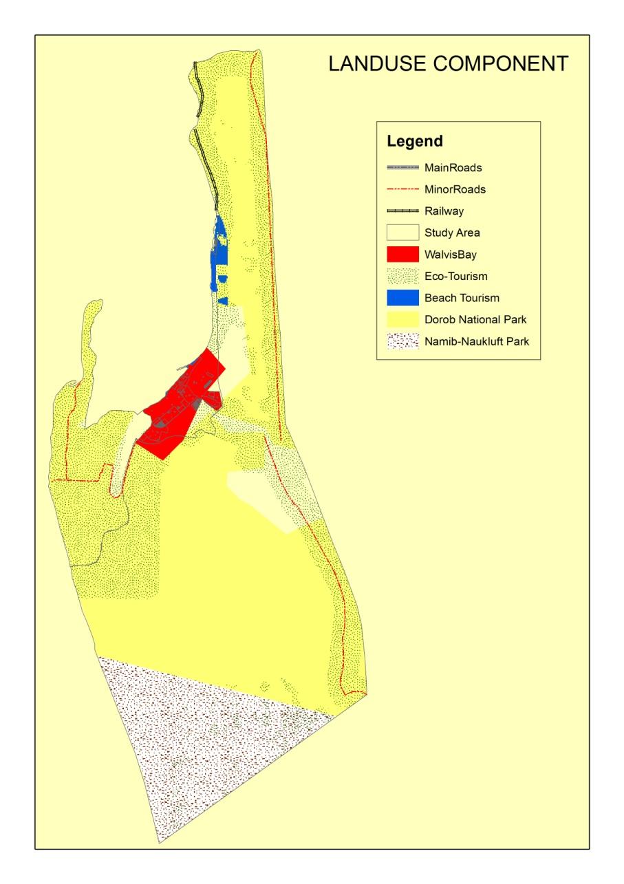
Figure 3.2: Current Land use zones in the study area
The following tourism and recreational activities are identified by (NACOMA, 2007) and
NACOMA (2009) studies (refer to Figure 1.5 below):
Desert tours Sightseeing trips Tours to Dune 7 Dune-boarding Quad biking 4X4 Off-road recreational driving Paragliding Scenic flights Filming and Photography Weddings, desert tented bouquets, picnics, annual 4x4 vasbyt events Walking, hiking and horse riding
Figure 3.3 : Tourism Business and Recreational Areas in the Dune Belt area
(NACOMA, 2009:42, 43 & 46)
As explained earlier, the KDDP and Trust was only established during 2009/10.
Therefore, unregulated tourism activities have been taking place in the Delta over the
past years. However, there are some regulated tourism-based activities led by Topnaars
community. The following activities are currently taking place in the Delta (Mufita, 2011
- Tour guide: 4x4 vehicles and quad bikes off-road driving,
- Walking trials, hiking and sand boarding
- Scenic Flights
- Tour operators marketing self-touring products in their itinerary
3.2 Sub Regional Concepts
The sub-regional concept of Walvis Bay as outlined in, provides for demarcation of
defined zones to accommodate existing and future land uses. The following is an extract
summary from the sub-regional concept document for Walvis Bay outlining the various
zones (see also, Figure 3.1 above & Figure 3.4 Below):
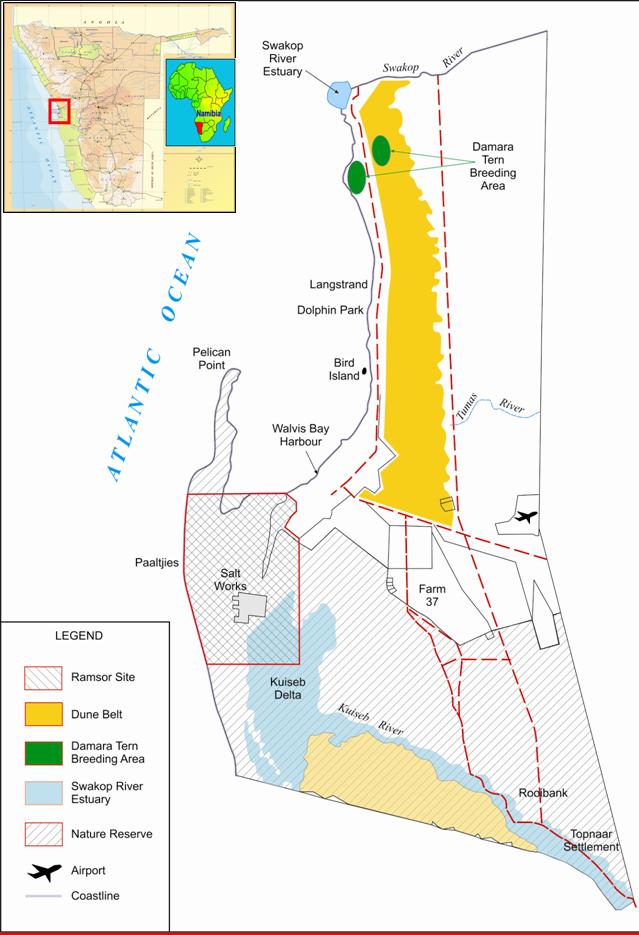
Figure 3.4 : Regional Location
Walvis Bay Nature Reserve: The zone is on the southern part of Walvis Bay,
roughly from the southern edges of Farms 29, 37 and 38 to the Kuiseb River.
The Lagoon, the Salt-Works and the Topnaar community settlement are
located in this zone… Since this zone is ecologically fragile, in such a way that
it supports unique and fascinating ecological communities, it is recommended
to be left free of any development other than those relating to cultural and eco-
tourism and/or aqua-culture/agriculture. All existing developments located in
this area should continue their activities in this area. However, new applications
of such kind will not be allowed;
Conservation: This area includes Farms owned by Council, part of the
coastline between Walvis Bay and Swakopmund, part of the dune belt and the
area immediately adjacent to the Swakop River Bed…Activities relating to
environmental conservation education, and/or eco-tourism. Off road vehicles
are prohibited in this area. Quad bikes and all other off road vehicles are not
allowed in this zone;
Recreation: Five areas are demarcated as recreation zones: South of the
Swakop River, East of Long Beach, North – West of the Tumas River, Dune 7,
and the coastline along Long Beach and Dolphin Park. Quad bikes as well as
all other off road vehicles will only be accommodated in the dunefield part of
this zone. All off road vehicles are to be led into the dunes via fixed tracks.
Quad bikes are prohibited in the beach area (i.e. the coastline along Long
Beach/Dolphin Park) of the recreation zone;
Industrial: The zone comprises of the areas demarcated for the heavy
industrial development behind the dune belt. Noxious and nuisance creating
industries should be located in this area;
Government: The zone is bounded by the Tumas River on the South and the
gravel road between Walvis Bay and Swakopmund on the West… Zone 5 will
permit only military related activities;
Land for Development: This includes the area just south of the Airport and
Dune 7 and South-East of the „built-up urban area‟ as well as the Long
Beach/Dolphin Park development. The node at Long Beach/Dolphin Park can
be strengthened. Developments at Long Beach/Dolphin Park have to abide to
this policy…With the exception of the Long Beach/Dolphin Park development,
any other proposed development in this area should be: scattered, not
agglomerated, to allow the dominant presence of the desert to be maintained,
and are subject to an Environmental Impact Assessment.
DESCRIPTION OF THE PROPOSED PROJECT
4.1 General Overview
Through the NACOMA Project Co-ordinating Office (PCO) and the Steering Committee, a
number of investment proposals were approved for implementation under the World Bank
Matching Grant support. The NACOMA Project Sub-component 3.2 is concerned with
provision of technical support and small matching grants for targeted investments in
specific project intervention sites. Kuiseb Delta Development Trust (KDDT) and Walvis
Bay Bird Paradise were among approved proposals and MG‟s recipients. Part of the
technical support is to identify activities to be funded through the NACOMA MG, to
facilitate a feasibility study and carry out an EIA screening to determine if there are
significant or no significant impacts requiring an assessment. However, the scope of this
consultancy is to also focus on other activities currently operating in the area as well as
identify potential eco-tourism and recreational activities in the Kuiseb Delta and Dune Belt
4.1.1 Kuiseb Delta Development Project/ Trust (KDDP/T)
Kuiseb Delta is located in Erongo region which is considered the hub of tourism in
Namibia. KDDP is located in an ideal tourism location - the meeting place of extreme
landscapes. On the one side is the Namib Desert, the oldest desert in the world while on
the other side is a massive lagoon and harbour flowing from the Atlantic Ocean. Both of
these landscapes lend themselves towards some of the most unique site seeing
opportunities in Namibia. The lagoon and harbour is home to a variety of species and a
large number of sea mammals and bird life. The Namib Desert on the other side is called
"The Living Desert", because of the large number of living species found there. Activities
include various different water related actions, like shore angling, boat angling, shark
angling, sightseeing and photographic boat cruises, sea kayaking and wind- and kite
surfing. Walvis Bay houses yearly one of the international legs of speed kite and wind
surfing. The proposed project provides additional activities in the coastal area. Envisaged
facilities and attendant activities will complement existing offerings. The additional
activities will boost current efforts to lengthen the average stay of tourists in the coastal
area (Nyakunu and Ndlovu, 2010).
The Topnaars community living in the Kuiseb Delta, submitted an application for a
Matching Grant to NACOMA with the main aim of establishing Community-Based
Tourism (CBT), called the Kuiseb Delta Development Project (KDDP). Upon approval of
the Matching Grant the KDDP submitted an application for a concession along the Kuiseb
Delta to MET. Conditions for concession applications required a feasibility report and
business plan. Subsequently, The Kuiseb Delta Development Trust (KDDT) was
registered on April 12, 2010 through a Trust Deed, in terms of the Trust Monies
Protection Act. The trust is a legal entity that can venture into formal commercial
agreements with business partners. It is an initiative being spearheaded by seven (7)
Trustees from the Topnaar community with the consent of the Topnaar Traditional
Authority. The trust comprises of 600 registered members. Clear guidelines on benefits
distribution, mandates and responsibilities have been drafted and a Steering Committee
comprising the Trustees is functioning. The concession which KDDT has applied for
spans the area east from Walvis Bay Meersig residential area, starting from the border of
Walvis Bay and state lands till Mile 7 reservoir including old Walvis Bay entry route near
the MWARD nursery (refer to Figure 4.1 below).
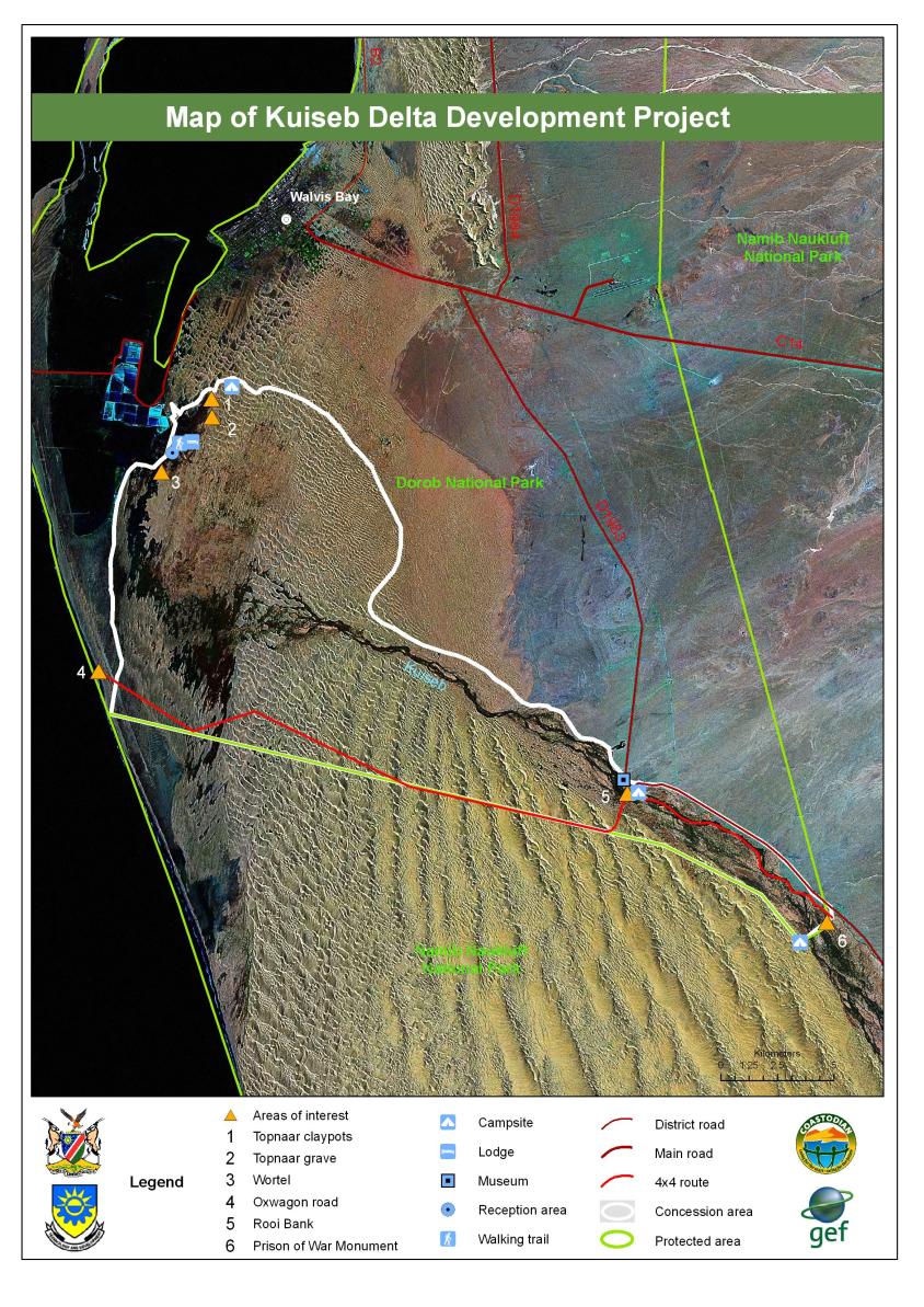
Figure 4.1: Kuiseb Delta Development Trust Concession Area (Nyakunu and Ndlovu, 2010)
The Kuiseb Delta Development Project (KDDP) seeks to offer more specialized tourism
services such as cultural tourism, educational/historical tourism and adventure tourism
through the provision of walking trails, scenic drives, dune drives, sand boarding, and
other activities relevant to its locality (Nyakunu and Ndlovu, 2010).
The feasibility study confirms that the project is significant and reasons for justification are as follow (Nyakunu and Ndlovu, 2010):
KDDP is a significant initiative since:
The Topnaar community will bring forth a rich cultural component to the trails. The
existing traditional customs and cultural harvesting of the !Nara presents another mile
stone in the promotion of cultural tourism. The historical and educational component
of the trail provides the overall experience.
The successful launch of the project will be another feature in the cap of CBNRM in
Namibia. It will be an additional opportunity to showcase Namibia‟s international
success in the promotion of CBRNMs.
Focus is on and around ecosystems of biodiversity importance i.e. bio-diversity being
conserved includes !Nara melons, Dune lark, Lichen fields, Dune habitats and gravel
plain habitats, Landscape aesthetics, Restriction of ORV traffic, etc.
It is aligned with community / local and national priorities such as empowering rural
communities through the provision of consumptive and non-consumptive rights over
natural resources, raising standard of living, creating employment opportunities,
alleviating poverty, etc.
The project will also include cottage industries and conservation issues.
The Kuiseb Delta is unparalleled in Southern Africa for its archaeology which provides
a continuum of 2000 years, including detailed evidence from the last 250 years. By
1990s, 235 sites had been identified with 75% being from pre-contact times and 25%
showing evidence of contact ranging in age from 15th to 20th century. Though well
preserved the sites are vulnerable to natural and human influences. For instance, the
removal of items is reducing the archaeological / historical value of the sites which is
important to the nation and paramount to the Topnaar people.
KDDT can sell the project and generate funding for both capital and running costs. The
KDDP can be easily operated at a marginal cash surplus but would rely heavily on
collections from membership fees, labour subsidies for construction and maintenance,
donations and subsidized supplies for construction and maintenance. According to the
KDDT business plan, it is assumed that revenues will be generated solely from activities
such as trails, camping and guiding fees. These income streams will cover sufficiently the
capital, construction and operating funding needs of the project (Nyakunu and Ndlovu,
4.1.2 Walvis Bay Bird Paradise
The application for a Matching Grant to establish a bird watch paradise in Walvis Bay was
also submitted to NACOMA PCO. Subsequently, the feasibility and business plan was
compiled to guide the construction and operation of the project. Setting up a bird
watching camp was welcomed by everybody spoken to, no matter whether they were
birders, people involved in tourism & NGO's or officials in government or public
institutions. It was actually often queried why a country with a very high ranking in its bird
variety has to date not seen an operation of this kind set up.
The Walvis Bay Bird Paradise is situated 1300m from the circle of the intersection of the
Swakop – Walvis Bay road (B2) and the road to the Walvis Bay Airport / into the Namib
(C14). The Walvis Bay sewerage ponds where the paradise camp is erected is about
200m form the road. The pond is the most north-east of the reticulation pans of the
reticulation plant. It is visible from the road; it can be accessed by a short graveled up
ramp from the main road. Separated by 2 dunes to the south-east is the water carrying
pan with a range of birds, both sweet water and sea water birds.
BASELINE ENVIRONMENT
5.1 General Overview
This section presents the description of the natural environment that may be affected by
activities proposed in the study area (Cunningham, 2011).
5.2 Climatic Setting
This section presents the climatic system of the Erongo Region where the study area is
situated. In essence, Erongo region is characterised by aridity. The following various are
described in detail;
5.2.1 Temperature
Maximum and the minimum temperatures in the Namibia Desert near the coast are
moderated by the effects of the cold Benguela current and the regular fog bank (Reptile
Uranium Namibia, 2010). According to Christian (2006), the hottest month is February,
when maximum air temperatures can reach 40˚C but the average maximum 25˚C – 30˚C.
The coldest month is August, when the average minimum temperature is between 8˚C
and 12˚C depending on the distance from the coast (Ibid).
5.2.2 Precipitation
The study area falls within a rainfall range averaging 15 mm at coast and 35 mm further
inland (Christian, 2006). The rainfall can be described as extremely variable, patchy and
unreliable along coastal areas (Mendelsohn et.al, 2009). The coastal area receives fog
and extends about 20 Km inland (Mendelsohn et. al, 2009). The fog is sufficient to
support at biodiversity in the project area.
5.2.3 Wind
Near the coast strong winds prevail, but westerly to south westerly winds are also
frequent. As the distance from the coast towards inland increases, the wind speed
generally decreases and its direction become more variable (Christian, 2006).
5.3 Vertebrate fauna expected in the Kuiseb Delta and Dune belt
area
5.3.1 Introduction
A desktop study (i.e. literature review) was conducted between 20 and 24 May 2011 on
the vertebrate fauna (e.g. reptiles, amphibians, mammals and birds) expected to occur in
the general area defined as the Kuiseb River delta and dune belt area between Walvis
Bay and Swakopmund.
This literature review was to determine the actual as well as potential vertebrate fauna
associated with the general area commonly referred to as the Southern Namib or
Southern Desert (Giess 1971, Mendelsohn et al. 2002, Van der Merwe 1983). This area
is bordered inland by the Central Namib or Central Desert (Giess 1971, Mendelsohn et al.
2002). Climatically the coastal area is referred to as Cool Desert with a high occurrence
of fog (van der Merwe 1983). The Namib Desert Biome makes up a large proportion
(32%) of the land area of Namibia with parks in this biome making up 69% of the
protected area network or 29.7% of the biome (Barnard 1998). Four of 14 desert
vegetation types are adequately protected with up to 94% representation in the protected
area network in Namibia (Barnard 1998). With the exception of municipal land, the area
falls within the recently proclaimed Dorob National Park. No communal and freehold
conservancies are located in the general area with the closest communal conservancy
being the ≠Gaingu Conservancy in the Spitzkoppe area approximately 100 km to the
northeast (Mendelsohn et al. 2002, NACSO 2010).
Two important coastal wetlands – i.e. Walvis Bay Wetlands and Sandwich Harbour – both
Ramsar sites, occur in the area. According to Curtis and Barnard (1998) the entire coast
and the Walvis Bay lagoon as a coastal wetland, are viewed as sites with special
ecological importance in Namibia. The known distinctive values along the coastline are
its biotic richness (arachnids, birds and lichens) with the Walvis Bay lagoon‟s importance
being its biotic richness and migrant shorebirds as well as being the most important
Ramsar site in Namibia. The Ramsar site covers 12 600 ha with regular counts of birds
varying between 37 000 and well over 100 000 individuals, albeit mainly migratory
species (Kolberg n.d.). The Walvis Bay wetland is considered the most important coastal
wetland in southern Africa and one of the top 3 in Africa (Shaw et al. 2004). The
Sandwich Harbour Ramsar site covers 16 500 ha and falls within the Namib-Naukluft
Park and enjoys full protection (Kolberg n.d.). This area is a centre of concentration of
migratory shorebirds, waders and flamingos regularly supporting over 142 000 and 50
000 birds during summer and winter, respectively (Kolberg n.d.).
The area is bordered by the Kuiseb River to the south (Walvis Bay area) and the Swakop
River to the north (Swakopmund area) with catchment areas of 15 500 km² and 30 100
km², respectively (Jacobson et al. 1995).
The central coastal region and the Walvis Bay area in particular, is regarded as "relatively
low" in overall (all terrestrial species) diversity (Mendelsohn et al. 2002). Overall
terrestrial endemism in the area on the other hand is "moderate to high" (Mendelsohn et
al. 2002).
The overall diversity and abundance of large herbivorous mammals (big game) is viewed
as "low to medium" with 1-2 species while overall diversity of large carnivorous mammals
(large predators) is determined at 4 species with brown hyena being the most important
with "medium" densities expected in the area (Mendelsohn et al. 2002).
It is estimated that at least 54 reptile, 7 amphibian, 42 mammal and 182 bird species
(breeding residents) are known to or expected to occur in the general/immediate Walvis
Bay/Swakopmund area of which a high proportion are endemics.
5.3.2 Methods
Literature review
A comprehensive and intensive literature review (i.e. desktop study) regarding the
reptiles, amphibians, mammals and birds that could potentially occur in the
general/immediate Kuiseb delta and dune belt area was conducted using as many
references as manageable. A list of the references consulted can be viewed in the
Reference section.
5.3.3 Results
5.3.3.1 Reptile Diversity
Table 1 indicates the reptile diversity known and/or expected to occur in the general
Kuiseb delta and dune belt area between Walvis Bay and Swakopmund:
Table 5.1. Reptile diversity known and/or expected to occur in the general Kuiseb delta and
dune belt area – i.e. Walvis Bay and Swakopmund areas.
Species: Scientific name
Species: Common name
Namibian
and legal
TURTLES AND TERRAPINS
Pelomedusa subrufa
Marsh/Helmeted Terrapin
Thread Snakes
Leptotyphlops occidentalis
Western Thread Snake
SARDB Peripheral
Leptotyphlops labialis
Damara Thread Snake
Burrowing Snakes
Xenocalamus bicolour bicolor
Bicoloured Quill-snouted
Typical Snakes
Lamprophis fuliginosus
Brown House Snake
Lycophidion capense
Pseudaspis cana
Dipsina multimaculata
Dwarf Beaked Snake
Psammophis trigrammus
Western Sand Snake
Psammophis notostictus
Karoo Sand Snake
Psammophis leightoni
Namib Sand Snake
namibensis Dasypeltis scabra
Common/Rhombic Egg
Aspidelaps lubricus
infuscatus Aspidelaps scutatus scutatus
Shield-nose Snake
Naya nigricincta
Black-necked Spitting Cobra
Bitis arietans
Bitis caudalis
Bitis peringueyi
Péringuey‟s Adder
Typhlosaurus braini
Brains‟s Blind Legless Skink
Typhlacontias brevipes
FitzSimmons‟ Burrowing
Trachylepis occidentalis
Western Three-striped Skink
Trachylepis striata wahlbergi
Trachylepis sulcata
Western Rock Skink
Trachylepis variegata
Variegated Skink
variegate
Old World Lizards
Heliobolus lugubris
Meroles anchietae
Shovel-snouted Lizard
Meroles cuneirostris
Wedge-snouted Desert
Meroles micropholidotus
Small-scaled Desert Lizard
Meroles reticulates
Reticulated Desert Lizard
Meroles suborbitalis
Spotted Desert Lizard
Pedioplanis breviceps
Short-headed Sand Lizard
Pedioplanis namaquensis
Namaqua Sand Lizard
Pedioplanis inornata
Plain Sand Lizard
Plated Lizards
Cordylosaurus subtessellatus
Dwarf Plated Lizard
Monitors
Varanus albigularis
CITES Appendix II
Safe to Vulnerable
Agama planiceps
Namibian Rock Agama
Chameleons
Bradypodion pumilum
Cape Dwarf Chameleon
Introduced alien
CITES Appendix II
Chamaeleo namaquensis
Namaqua Chameleon
CITES Appendix II
Afroedura africana africana
African Flat Gecko
Chondrodactylus angulifer
Giant Ground Gecko
namibensis Narudasia festiva
Pachydactylus bicolour
Velvety Thick-toed Gecko
Pachydactylus kockii
Koch‟s Thick-toed Gecko
Pachydactylus turneri
Turner‟s Thick-toed Gecko
Pachydactylus scherzi
Schertz‟s Thick-toed Gecko
Pachydactylus rugosus
Rough Thick-toed Gecko
Pachydactylus weberi werneri Weber‟s Thick-toed Gecko
Palmatogecko rangei
Wed-footed Gecko
Ptenopus carpi
Carp‟s Barking Gecko
Ptenopus garrulus maculatus
Common Barking Gecko
Ptenopus kocki
Kock‟s Barking Gecko
Rhoptropus afer
Common Namib Day Gecko
Rhoptropus boultoni
Boulton‟s Namib Day Gecko
Rhoptropus bradfieldi
Bradfield‟s Namib Day
Namibian conservation and legal status according to the Namibian Conservation
Ordinance of 1975 – Griffin (2003)
Source for literature review: Alexander and Marais (2007), Branch (1998), Branch
(2008), Boycott and Bourquin 2000, Broadley (1983), Buys and Buys (1983),
Cunningham (2006), Griffin (1998a), Griffin (2003), Hebbard (n.d.), Marais (1992), Tolley
and Burger (2007)
Approximately 261 species of reptiles are known or expected to occur in Namibia thus
supporting approximately 30% of the continents species diversity (Griffin 1998a). At least
22% or 55 species of Namibian lizards are classified as endemic. The occurrence of
reptiles of "conservation concern" includes about 67% of Namibian reptiles (Griffin
1998a). Emergency grazing and large scale mineral extraction in critical habitats are
some of the biggest problems facing reptiles in Namibia (Griffin 1998a). The overall
reptile diversity and endemism in the Walvis Bay/Swakopmund area is estimated at
between 31-50 species and 17-24 species, respectively (Mendelsohn et al. 2002). Griffin
(1998a) presents figures of between 1-20 and 9-10 for endemic lizards and snakes,
respectively, from the general central coastal part of Namibia.
According to the literature review at least 54 species of reptiles are expected to occur in
the general Walvis Bay/Swakopmund area with 27 species being endemic – i.e. 50%
endemic, 1 species (Varanus albigularis) as vulnerable, 2 species as rare and
insufficiently known while 4 species have some form of international conservation status.
These consist of at least 17 snakes (2 thread snakes, 1 burrowing snake, 14 typical
snakes) of which 6 species (35%) are endemic, 1 terrapin, 16 lizards (50% endemic), 1
monitor, 1 agama, 2 chameleons (although the Cape Dwarf Chameleon is endemic to
South Africa it was introduced to gardens in the Walvis Bay area and thus does not occur
there naturally – i.e. alien) and 16 geckos (81% endemic).
Lizards (16 species with 8 species being endemic) and Gecko‟s (16 species with 13
species being endemic) are the most important group of reptiles expected from the
Walvis Bay/Swakopmund area. Namibia with approximately 129 species of lizards
(Lacertilia) has one of the continents richest lizard fauna (Griffin 1998a). Geckos
expected and/or known to occur in the Walvis Bay/Swakopmund area have the highest
occurrence of endemics (81%) of all the reptiles in this area. Griffin (1998a) confirms the
importance of the gecko fauna in Namibia. Both thread snakes expected from the area
are classified as endemic.
Due to the fact that reptiles are an understudied group of animals, especially in Namibia,
it is expected that more species may be located in the general Walvis Bay/Swakopmund
area than presented above.
5.3.3.2 Amphibian Diversity
Table 2 indicates the amphibian diversity known and/or expected to occur in the general
Kuiseb delta and dune belt area between Walvis Bay and Swakopmund:
Table 5.2. Amphibian diversity known and/or expected to occur in the general Kuiseb delta
and dune belt area – i.e. Walvis Bay and Swakopmund areas.
Species: Scientific name
Species: Common name
Poyntonophrynus dombensis
Poyntonophrynus hoeschi
Amietophrynus poweri
Power‟s Toad or Western Olive Toad
Rain Frogs
Breviceps adspersus
Common/Bushveld Rain Frog
Rubber Frog
Phrynomantis annectens
Marbled Rubber Frog
Bull and Sand Frogs
Tomopterna tandyi
Tandy‟s Sand Frog
Platannas
Xenopus laevis
Source for literature review: Carruthers (2001), Channing (2001), Channing and Griffin
(1993), Du Preez and Carruthers (2009), Passmore and Carruthers (1995)
Amphibians are declining throughout the world due to various factors of which much has
been ascribed to habitat destruction. Basic species lists for various habitats are not
always available with Namibia being no exception in this regard while the basic ecology of
most species is also unknown. Approximately 4 000 species of amphibians are known
worldwide with just over 200 species known from southern Africa and at least 57 species
expected to occur in Namibia. Griffin (1998b) puts this figure at 50 recorded species and
a final species richness of approximately 65 species, 6 of which are endemic to Namibia.
This "low" number of amphibians from Namibia is not only as a result of the generally
marginal desert habitat, but also due to Namibia being under studied and under collected.
Most amphibians require water to breed and are therefore associated with the permanent
water bodies, mainly in northeast Namibia.
The dry sandy coastal desert (Namib) and saline coastal areas are poor habitat for
amphibians. Although the ephemeral Kuiseb and Swakop Rivers reach the sea in the
Walvis Bay and Swakopmund areas, it seldom flows with temporary freshwater pools
being rare close to the coast. Other water bodies in the area are saline of nature and not
suitable habitat for amphibians. Gardens in Walvis Bay, Lang Strand and Swakopmund
can be suitable habitat and amphibians are known to occur here usually after having
being transported from elsewhere (Pers obs.). Overall, the saline coastal habitats are
marginal for amphibians. According to Mendelsohn et al. (2002), the overall frog diversity
in the Walvis Bay/Swakopmund area is estimated at between 1-3 species. Griffin (1998b)
puts the species richness in the general area between 1-2 species.
According to the literature review, up to 7 species of amphibians can occur in suitable
habitat in the general Walvis Bay/Swakopmund area. The area is under represented,
with 3 toads and 1 species each for rain, rubber and sand frog and platanna known
and/or expected (i.e. potentially could be found in the area) to occur in the area. Three
species (43%) namely Poyntonophrynus dombensis, Poyntonophrynus hoeschi and
Phrynomantis annectens are classified as endemic to Namibia (Griffin 1998b) while all 7
species are classified as "least concern" by the IUCN (IUCN 2010).
The Kuiseb and Swakop Rivers flooded for lengthy periods during the unusually high
2011 rainy season. This could have resulted in amphibians being transported into the
area which otherwise remains generally poor habitat.
5.3.3.3 Mammal Diversity
Table 3 indicates the mammal diversity known and/or expected to occur in the general
Kuiseb delta and dune belt area between Walvis Bay and Swakopmund:
Table 5.3. Mammal diversity known and/or expected to occur in the general Kuiseb delta
and dune belt area – i.e. Walvis Bay and Swakopmund areas.
Species: Scientific name
Species: Common name
Namibian
and legal
status
Eremitalpa granti
Grant‟s Golden Mole
Elephant Shrews
Macroscelides
Round-eared Elephant-
proboscideus
flavicaudatus
Bats
Lissonycteris angolensis
*Angolan Soft-furred Fruit
Tadarida aegyptiaca
Egyptian Free-tailed Bat
Cistugo seabrai
Namibian Wing-gland Bat
2Near Threatened
Laephotis namibensis
Namib Long-eared Bat
Nycteris thebaica
Common Slit-faced Bat
Rhinolophus clivosus
Geoffroy‟s Horseshoe Bat
1Near Threatened
Rhinilophus darling
Darling‟s Horseshoe Bat
1Near Threatened
Rhinolophus capensis
*Cape Horseshoe Bat
1Near Threatened;
2Near Threatened
Taphozous mauritianus
*Mauritanian Tomb Bat
Chaerephon ansorgei
*Ansorge‟s Free-tailed Bat
Sauromys petrophilus
Roberts‟s Flat-headed Bat
Miniopterus natalensis
Natal Long-fingered Bat
1Near Threatened
Eptesicus hottentotus
Long-tailed Serotine
Neoromicia zuluensis
Pipistrellus rueppellii
*Rüppel ‟s Pipistrel e
Hares and Rabbits
Lepus capensis
Rats and Mice
Parotomys littledalei
Littledale‟s Whistling Rat
1Near Threatened
namibensis
Rhabdomys pumilio
Mus musculus
Aethomys chrysophilus
Micaelamys (Aethomys)
Namaqua Rock Mouse
namaquensis Rattus rattus
Rattus norvegicus
Desmodillus auricularis
Short-tailed Gerbil
Gerbillurus paeba infernus
Hairy-footed Gerbil
Gerbillurus tytonis
Dune Hairy-footed Gerbil
Gerbillurus setzeri
Setzer‟s Hairy-footed Gerbil
or Namib Brush-tailed Gerbil
Petromyscus collinus
Pygmy Rock Mouse
Mastomys coucha
Southern Multimammate
Petromys typicus
1Near Threatened
Carnivores
Hyaena brunnea
1Near Threatened
2Near Threatened
Crocuta crocuta
1Near Threatened
Felis silvestris
African Wild Cat
CITES Appendix II
Vulpes chama
Canis mesomelas
Black-backed Jackal
Ictonyx striatus
Suricata suricatta
marjoriae
Antelopes
Sylvicapra grimmia
Antidorcas marsupialis
Oryx gazelle
1SARDB (2004); 2IUCN (2010)
* Unconfirmed bat species although potentially could occur in area according to habitat
modelling (Monadjem et al. 2010)
Source for literature review: De Graaff (1981), Griffin (2005), Estes (1995), Joubert and
Mostert (1975), Monadjem et al. (2010), Skinner and Smithers (1990), Skinner and
Chimimba (2005) and Taylor (2000)
Namibia is well endowed with mammal diversity with at least 250 species occurring in the
country. These include the well known big and hairy as well as a legion of smaller and
lesser-known species. Currently 14 mammal species are considered endemic to Namibia
of which 11 species are rodents and small carnivores of which very little is known. Most
endemic mammals are associated with the Namib and escarpment with 60% of these
rock-dwelling (Griffin 1998c). According to Griffin (1998c) the endemic mammal fauna is
best characterized by the endemic rodent family Petromuridae (Dassie rat) and the rodent
genera Gerbillurus and Petromyscus. The overall mammal diversity in the Walvis Bay
area is estimated at between 16-30 species with 3-4 species being endemic to the area
(Mendelsohn et al. 2002).
Overall terrestrial diversity – all species – is classified as "low" in the western coastal
parts of Namibia (Mendelsohn et al. 2002). The overall diversity (1-2 species) and
abundance of large herbivorous mammals is low in the Walvis Bay area with Springbok
and Oryx having the highest density of the larger species (Mendelsohn et al. 2002). The
overall abundance and diversity of large carnivorous mammals is relatively high (4
species) in the Walvis Bay area with Brown Hyena having the highest density of the
larger species (Mendelsohn et al. 2002).
According to the literature review, up to 42 species of mammals are known and/or
expected to occur in the general Walvis Bay/Swakopmund area of which 11 species
(29.1%) are classified as endemic. According to the Namibian legislation 1 species is
classified as rare, 3 species as vulnerable, 4 species as insufficiently known, 3 species as
invasive aliens, 2 species as huntable game, 1 species as problem animal while 2
species (both bats) are not listed. Eleven species are listed with various international
conservation statuses of which 2 species are classified as vulnerable (Eremitalpa granti
and Cistugo seabrai) and 8 species as near threatened by the SARDB (SARDB 2004).
The IUCN (IUCN 2010) classifies 3 species as near threatened (Cistugo seabrai,
Rhinolophus capensis and Hyaena brunnea) while 1 species is classified as a CITES
Appendix II species.
The House Mouse (Mus musculus) and the rats Rattus rattus and Rattus norvegicus are
viewed as invasive aliens to the area. Mus musculus are generally known as casual
pests and not viewed as problematic although they are known carriers of "plague" and
can cause economic losses. The biggest problem with the Rattus species is economic
losses and garden pests along the coast (Griffin 2003). Mammal species probably
underrepresented in the above mentioned table for the general area are the bats as this
group has not been well documented from the arid western parts of Namibia.
At least 40.5% and 35.7% of the mammalian fauna that occur or are expected to occur in
the Walvis Bay/Swakopmund area are represented by rodents (17 species) and bats (15
species) of which 9 species (21.4%) are endemic to Namibia. Some species such as
Petromys typicus are not expected to occur in the dune belt area as they typically favour
rocky habitat and are known to occur behind the dune belt in such habitat. Habitats often
not valued as unique are the dune hummocks and seemingly barren gravel plains along
the coast. Habitat alteration and overutilization are the two primary processes
threatening most mammals (Griffin 1998c).
5.3.3.4 Avian Diversity
Table 4 indicates the bird diversity known and/or expected to occur in the general Kuiseb
delta and dune belt area between Walvis Bay and Swakopmund:
Table 5.4. Bird diversity known and/or expected to occur in the general Kuiseb delta and
dune belt area – i.e. Walvis Bay and Swakopmund areas. This table excludes migratory
birds (e.g. Petrel, Albatross, Skua, etc.) and species breeding extralimital (e.g. stints,
sandpipers, etc.) and rather focuses on birds that are breeding residents or can be found
in the area during any time of the year. This would imply that many more birds (e.g.
Palaearctic migrants) could occur in the area depending on "favourable" environmental
Table 5.4. Bird diversity known and/or expected to occur in the general Kuiseb delta and
dune belt area – i.e. Walvis Bay and Swakopmund areas.
Species: Scientific name
Species: Common name
Status: Southern
Struthio camelus
Podiceps cristatus
Great Crested Grebe
Tachybaptus ruficollis
Podiceps nigricollis
Black-necked Grebe
Pelecanus onocrotalus
Great White Pelican
Pelecanus rufescens
Pink-backed Pelican
Phalacrocorax lucidus
Morus capensis
Breeding endemic
Phalacrocorax capensis
Near-threatened;
Breeding endemic
Phalacrocorax neglectus
Phalacrocorax africanus
Phalacrocorax coronatus
Crowned Cormorant
Anhinga melanogaster
Ardea cinerea
Ardea melanocephala
Black-headed Heron
Ardea purpurea
Egretta garzetta
Egretta intermedia
Yellow-billed Egret
Egretta alba
Egretta ardesiaca
Bubulcus ibis
Ardeola ralloides
Ixobrychus minutes
Scopus umbretta
Ciconia nigra
Phoenicopterus ruber
Greater Flamingo
Phoenicopterus minor
Dendrocygna viduata
Alopochen aegyptiacus
Anas capensis
Anas hottentota
Anas erythrorhyncha
Anas smithii
Netta erythrophthalma
Southern Pochard
Sagittarius serpentarius
Gyps africanus
White-backed Vulture
Aegypius tracheliotus
Lappet-faced Vulture
Circaetus pectoralis
Black-chested Snake-
Elanus caeruleus
Black-shouldered Kite
Aquila verreauxii
Verreaux‟s Eagle
Aquila rapax
Polemaetus bellicosus
Buteo augur
Melierax canorus
Southern Pale Chanting
Falco peregrines
Peregrine Falcon
Falco biarmicus
Falco chicquera
Red-necked Falcon
Falco rupicolus
Falco rupicoloides
Francolinus adspersus
Red-billed Francolin
Trunix sylvatica
Kurrichane Buttonquail
Porphyrio porphyrio
African Purple Swamphen
Gallinula chloropus
Fulica cristata
Red-knobbed Coot
Ardeotis kori
Neotis ludwigii
Ludwig‟s Bustard
Eupodotis rueppellii
Rüppell‟s Korhaan
Eupodotis afra
Actophilornis africanus
Rostratula benghalensis
Haematopus moquini
Near threatened;
Charadrius marginatus
White-fronted Plover
Charadrius pallidus
Chestnut-banded Plover
Charadrius pecuarius
Kittlitz‟s Plover
Charadrius tricollaris
Three-banded Plover
Vanellus armatus
Blacksmith Lapwing
Recurvirostra avosetta
Himantopus himantopus
Black-winged Stilt
Burhinus capensis
Spotted Thick-knee
Cursorius rufus
Burchel ‟s Courser
Rhinoptilus africanus
Double-banded Courser
Larus dominicanus
Larus cirrocephalus
Grey-headed Gull
Larus hartlaubii
Hartlaub‟s Gull
Sterna bergii
Sterna balaenarum
Near threatened;
Breeding endemic
Chlidonias hybridus
Pterocles namaqua
Namaqua Sandgrouse
Pterocles bicinctus
Columba guinea
Columba livea
Streptopelia capicola
Cape Turtle Dove
Streptopelia senegalensis
Streptopelia capicola
Cape Turtle-Dove
Oena capensis
Agapornis roseicollis
Rosy-faced Lovebird
Corythaixoides concolor
Grey Go-away-bird
Tyto alba
Otus leucotis
Southern White-faced
Glaucidium perlatum
Pearl-spotted Owlet
Bubo africanus
Spotted Eagle Owl
Bubo lacteus
Caprimulgus tristigma
Freckled Nightjar
Apus bradfieldi
Bradfield‟s Swift
Colius colius
White-backed Mousebird
Urocolius indicus
Red-faced Mousebird
Ceryle rudis
Merops hirundineus
Swallow-tailed Bee-eater
Upupa epops
Phoeniculus cyanomelas
Tockus monteiri
Monteiro‟s Hornbil
Tockus nasutus
African Grey Hornbill
Lybius leucomelas
Dendropicos fuscescens
Cardinal Woodpecker
Mirafra sabota
Mirafra curvirostris
Long-billed Lark
Calendulauda
erythrochlamys Chersomanes albofasciata
Spike-heeled Lark
Calandrella cinerea
Alauda starki
Ammomanopsis grayi
Certhilauda subcoronata
Karoo Long-billed Lark
Eremopterix verticalis
Grey-backed Sparrowlark
Hirundo fuligula
Riparia paludicola
Brown-throated Martin
Dicrurus adsimilis
Fork-tailed Drongo
Corvus capensis
Corvus albus
Parus cinerascens
Anthoscopus minutes
Cape Penduline Tit
Turdoides bicolour
Pycnonotus nigricans
African Red-eyed Bulbul
Monticola brevipes
Short-toed Rock Thrush
Namibornis herero
Oenanthe monticola
Mountain Wheatear
Cercomela familiaris
Cercomela tractrac
Cercomela schlegelii
Myrmecocichla formicivora
Erythropygia paena
Parisoma subcaeruleum
Chestnut-vented Tit-
Parisoma layardi
Layard‟s Tit-Babbler
Zosterops pallidus
Orange River White-eye
Sylvietta rufescens
Long-biled Crombec
Eremomela icteropygialis
Yellow-bellied Eremomela
Eremomela gregalis
Acrocephalus baeticatus
African Reed-Warbler
Acrocephalus gracilirostris
Lesser Swamp-Warbler
Cisticola aridulus
Desert Cisticola
Cisticola subruficapilla
Grey-backed Cisticola
Cisticola juncidis
Zitting Cisticola
Prinia flavicans
Black-chested Prinia
Melaenornis mariquensis
Marico Flycatcher
Bradornis infuscatus
Muscicapa striata
Spotted Flycatcher
Batis pririt
Motacilla capensis
Anthus navaeseelandiae
Richard‟s Pipit
Anthus similes
Long-billed Pipit
Anthus vaalensis
Tchagra australis
Brown-crowned Tchagra
Lanius collaris
Laniarius atrococcineus
Crimson-breasted Shrike
Nilaus afer
Telophorus zeylonus
Creatophora cinerea
Wattled Starling
Lamprotornis nitens
Cape Glossy Starling
Onychognathus nabouroup
Pale-winged Starling
Chalcomitra senegalensis
Scarlet-chested Sunbird
Nectarinia mariquensis
Nectarinia fusca
Passer domesticus
Passer motitensis
Passer melanurus
Passer griseus
Southern Grey-headed
Sporopipes squamifrons
Scaly-feathered Finch
Plocepasser mahali
White-browed Sparrow-
Philetairus socius
Ploceus velatus
Southern Masked Weaver
Quelea quelea
Red-billed Quelea
Euplectes orix
Southern Red Bishop
Estrilda erythronotos
Black-faced Waxbill
Estrilda astrild
Amadina erythrocephala
Red-headed Finch
Vidua regia
Shaft-tailed Whydah
Serinus alario
Black-headed Canary
Serinus flaviventris
Crithagra atrogulariis
Black-throated Canary
Serinus albogularis
White-throated Canary
Emberiza capensis
Emberiza tahapisi
Cinnamon-breasted
Emberiza impetuani
Lark-like Bunting
Endangered, vulnerable, near threatened, etc. (IUCN 2010) – status international
Endemic, near endemic (Hockey et al. 2006) – status southern Africa
Source for literature review: Brown et al. (1998), Hockey et al. (2006), Komen (n.d.),
Maclean (1985) and Tarboton (2001)
The Walvis Bay Wetland is viewed as the most important coastal wetland in southern
Africa attracting between 80 000 (winter) and 250 000 (summer) individual birds of 40-50
species in some places (Shaw et al. 2004). Although Namibia‟s avifauna is comparatively
sparse compared to the high rainfall equatorial areas elsewhere in Africa, approximately
658 species have already been recorded with a diverse and unique group of arid
endemics (Brown et al. 1998, Maclean 1985). Fourteen species of birds are endemic or
near endemic to Namibia with the majority of Namibian endemics occurring in the
savannas (30%) of which ten species occur in a north-south belt of dry savannah in
central Namibia (Brown et al. 1998). Bird diversity is viewed as medium in the Walvis
Bay/Swakopmund area with 141-170 species (this would include migrant species)
estimated with at least 1-3 species being endemic to the general area (Mendelsohn et al.
According to the literature review, at least 182 species of terrestrial ["breeding residents"]
birds occur and/or could occur in the general Walvis Bay/Swakopmund area at any time
(Hockey et al. 2006, Maclean 1985, Tarboton 2001). Although many of the species
mentioned in Table 4 do not occur permanently in the general area, environmental
conditions such as "berg winds" ("East weather" – local vernacular) often brings
unexpected avian guests to the coastal areas although these are not resident all year
(Pers obs). All the migrant species (Walvis Bay and surroundings is world renowned for
its Palaearctic migrants) have been excluded here, although the Bay area serves as an
important feeding ground for a variety of mainly aquatic species.
Seven of the 14 Namibian endemic bird species (50% of all Namibian endemic species or
4% of the species expected to occur in the area) can or are likely to occur in the general
Walvis Bay/Swakopmund area. Furthermore, 2 species are classified as specially
protected; 3 species as vulnerable and 1 species as endangered (IUCN 2010).
According to the southern African status for birds, 5 species are classified as near-
threatened, 3 species as vulnerable, 34 species as near endemic, 12 species as endemic
and 3 species as breeding endemics (Hockey et al. 2006).
The Walvis Bay wetland is considered the most important coastal wetland in southern
Africa and one of the top 3 in Africa (Bethune et al. 2007) and supports mainly Palaearctic
migrants, often comprising up to 88% of the birds – e.g. up to 1% of the global Chestnut-
banded Plover (approximately 2 000 individuals) are expected to occur in the Walvis Bay
area (Whitelaw et al. 1978). Between 70 000 and 100 000 birds in winter and up to 250
000 in spring are supported by the wetland (Bethune et al. 2007). The Namib coast is
especially important for 8 species and in terms of global populations it supports >90% of
the world‟s Chestnut-banded Plovers (Charadrius pallidus); 31% of Cape Teals (Anas
capensis); and 26% of African Black Oystercatchers (Haematopus moquini). In terms of
African endemic races it supports: >90% of the Black-necked Grebe (Podiceps nigricollis
gurneyi); and 33% of the White-fronted Plover (Charadrius m. Marginatus); and in terms
of southern African sub-continental populations it supports 31% of Pied Avocets
(Recurvirosta avocetta), 13.7% of Greater Flamingos (Phoenicopterus roseus) and 10.3%
of Lesser Flamingos (Phoenicopterus minor) (Williams and Simmons 2008a).
Furthermore, up to 200 000 Holarctic shorebirds are supported seasonally along the
Namibian coast belonging largely to 12 annually occurring species, of which 5 species
occur in numbers that form a significant proportion of the southern African flyway
populations – e.g. Curlew Sandpiper (Calidris ferruginea 35%); Sanderling (C. alba 32%);
Ruddy Turnstone (Arenaria interpres 17.5%); Grey Plover (Pluvialis squatarola 7.8%) and
Red Knot (Calidris canutus 1.6%) (Williams and Simmons 2008b). According to
Simmons and Brown (2009) 28 wetland bird species are of special concern in Namibia.
The Walvis Bay and Sandwich Harbour wetlands are also classified as Ramsar sites (i.e.
Namibia is signatory to the Ramsar Convention protecting important wetland sites) as
well as globally Important Birding Area (IBA‟s) (Simmons 1998a). Another IBA in close
proximity to Walvis Bay and the Sandwich Harbour area (Global IBA, Marine Reserve and
Namib-Naukluft Park) are the Mile 4 Salt works (Swakopmund area – Global IBA, Private
Nature Reserve) (Simmons 1998a). Coastal areas and wetlands are immensely
important as 8 and 34 bird species are classified as Critically Endangered, Endangered or
Vulnerable in each of the biomes (i.e. Coastal areas and Wetlands), respectively
(Simmons 1998a).
A recently published summer bird count from the general area indicate 38 species (116
118 individuals) at Walvis Bay; 24 species (1 464 individuals) at the Walvis Bay sewerage
ponds; 18 species (134 individuals) at the Swakop River mouth and 34 species (84 011
individuals) at Sandwich Harbour (Kolberg 2010). Of these, waders/shorebirds ( 50
000), gulls/terns/skimmers ( 30 000) and grebes ( 10 000) were the most numerous at
Walvis Bay indicating the importance of the general area for a variety of birds.
5.3.3.5 Important Species
The high percentage of endemic reptile species (50%) known and/or expected to occur in
the general Walvis Bay/Swakopmund area underscores the importance of this area for
reptiles. Reptile species of concern are the 2 thread snakes (Leptotyphlops occidentalis
and L. labialis) as well as the sand burrowing/dwelling species such as Bitis peringueyi
and the various Meroles species, especially Meroles micropholidotus classified as
endemic and rare, as well as the high proportion (81%) of endemic gecko (e.g.
Pachydactylus species) species of which very little is known about their ecological role
and actual status in Namibia. The seemingly barren sandy dune and gravel plain areas
around Walvis Bay/Swakopmund are host to a variety of reptile fauna not often expected
and/or acknowledged. Poorly planned and executed development and recreation
activities could affect these species negatively.
Amphibians
Amphibians are generally not viewed as extremely important in saline coastal areas
which are marginal habitat for most amphibians. Although 43% of the amphibians
expected to occur in the general area are endemic to Namibia they are expected to occur
further inland – i.e. the Kuiseb and Swakop Rivers and rocky outcrops with temporary
pools associated with these landforms, etc. – and not directly associated with the dune
belt between Walvis Bay and Swakopmund. The endemic Phrynomantis annectens is
probably the amphibian of greatest concern in the area although it occurs widespread
throughout large parts of Namibia.
Endemic mammals expected to occur in the general Walvis Bay area make up a relatively
large percentage (29%) of the mammals known and/or expected from the area. Endemic
mammal species of concern include the mole Eremitalpa granti and the two bats
Laephotis namibensis and Cistugo seabrai as well as the Hairy-footed Gerbils
(Gerbillurus sp.). Both bats are very poorly known with only a few records from the
general area making them particularly important. The predator of concern is Hyaena
brunnea which is classified locally as Insufficiently Known, probably Vulnerable; with an
international status of Vulnerable (SARDB 2004, IUCN 2010).
The high proportion of endemic birds of which 50% (7 of 14 species) are endemic to
Namibia and which are known and/or expected to occur in the general Walvis
Bay/Swakopmund area is important and should be taken into consideration regarding
development in the area. Seabirds tend to be more mobile than most other birds with the
highest species diversity and abundance along nutrient-rich waters such as the Benguela
upwelling system along the Namibian coastline (Hockey et al. 2006). Species of greatest
concern include all the endemics (e.g. Dune and Gray‟s Larks) as well as Morus capensis
(Vulnerable – IUCN 2010), Phalacrocorax capensis (Near threatened – IUCN 2010),
Phalacrocorax neglectus (Endangered – IUCN 2010), Phalacrocorax coronatus (Near
threatened – IUCN 2010), Phoenicopterus minor (Endangered – IUCN 2010),
Haematopus moquini (Near threatened – IUCN 2010), Charadrius pallidus (Near
threatened – IUCN 2010) and Sterna balaenarum (Near threatened – IUCN 2010).
The Namibian coast is extremely important for the Chestnut-banded Plover (Charadrius
pallidus) with Walvis Bay and Sandwich Harbour home to more than 80% of the species
in Africa during certain parts of the year (Simmons et al. 2007). Cape Cormorant
(Phalacrocorax capensis) and Crowned Cormorant (Phalacrocorax coronatus), which
breed at the guano platforms along the Namibian coast, are other species of concern as
fluctuating numbers are often a result of anthropomorphic influences (Crawford et al.
2007, Hamukwaya and Cunningham 2007). However, the Damara Tern (Sterna
balaenarum) which breeds in the gravel plain and sandy beach areas in the general area
is the species possibly most threatened by development in the immediate Walvis
Bay/Swakopmund area. With 98% of the Damara Tern breeding population being in
Namibia (Braby 2010a; Braby 2011; Crawford and Simmons 1997); very low inter-colony
dispersal rates with only 70 known colonies (Braby 2011), the importance of the general
Walvis Bay/Swakopmund cannot be stressed enough. Furthermore, some of the densest
colonies – Caution Reef/Horse Graves – are located in this area (Braby 2010b).
Disturbance and urbanisation, especially off-road vehicles, impact on breeding success
and consequently pose the biggest threat to Damara Terns along the Namibian coast
(Braby et al. 2001, Braby 2011, Braby and Braby 2002). Another species threatened by
off-road driving, which also occur along Walvis Bay/Swakopmund coast, are African Black
Oystercatchers (Haematopus moquini) (Watson et al. 1996).
The Palaearctic migrants visiting the Walvis Bay lagoon area – mainly during the summer
– are also of great importance with disturbance to the feeding area impacting globally on
these birds. The larger birds which follow local migration patterns such as the 2 Flamingo
species (Walvis Bay – Etosha NP – Botswana) and the Great White Pelican (Walvis Bay
– Etosha NP – Hardap Dam) would also be of concern. Flamingos have shown a
downward trend in southern Africa with the Namibian coast regularly supporting 84% (40
000 to 47 000) of the Greater Flamingos and 85% (34 000 to 40 000) of the Lesser
Flamingos, respectively (Simmons 1998c). This indicates the importance of the coastal
areas for these species.
5.3.4 Conclusion
It is estimated that at least 54 species of reptile, 7 amphibian, 42 mammal and 182 bird
(breeding residents) species occur in the general/immediate Walvis Bay/Swakopmund
area of which a large proportion are endemics. Endemics include at least 50% of the
reptiles, 43% of the amphibians, 29% of the mammals and 4% (7 of 14 endemic species)
of all the breeding and/or resident birds known and/or expected to occur in the general
Walvis Bay/Swakopmund area.
The reptile diversity is varied in the area with a high percentage of unique and/or endemic
species (50%). Species such as the well known sidewinder or Péringuey‟s Adder as well
as the sand diving Meroles species and the various unique and mostly endemic
Pachydactylus geckos, are important in the general area.
Due to the general saline and sandy conditions as well as the lack of permanent surface
water, amphibians are not well represented in the general area.
Mammals, especially small mammals (bats and rodents) are well represented in the area
with 29% classified as endemic to Namibia.
Aquatic birds, especially migrant waders, are well represented in the Bay area with many
more species known and expected to occur in the area, but excluded here due to being
highly nomadic and not necessarily permanently associated with the area. A high
percentage of endemic species (7 of the 14 Namibian endemic species) are known or
expected to occur in the general Walvis Bay/Swakopmund area. The most problematic
species are those associated with and/or reliant on the mud flats in the Bay area (e.g.
migrant waders) or coastal breeding species such as the endemic Damara Tern and
species following local movement patterns between the coast and inland water bodies
(e.g. Flamingo‟s and Pelicans).
Development and recreation (e.g. "dune bashing" and quad bikes) are possibly the
biggest threats to vertebrate fauna, especially reptiles and ground breeding birds, in the
Kuiseb delta and dune belt area between Walvis Bay and Swakopmund.
Species most likely to be adversely affected by coastal development would be the avian
fauna specifically associated with these areas. As all development have potential
negative environmental consequences, identifying the most important faunal species
including high risk habitats beforehand, coupled with environmentally acceptable
mitigating factors, lessens the overall impact of such development.
5.4. Flora expected in the Kuiseb delta and dune belt area
5.4.1 Introduction
A desktop study (i.e. literature review) was conducted between 20 and 24 May 2011 on
the flora (e.g. trees/shrubs and grass) expected to occur in the general area defined as
the Kuiseb River delta and dune belt area between Walvis Bay and Swakopmund.
This literature review was to determine the actual as well as potential flora associated
with the general area commonly referred to as the Southern Namib or Southern Desert
(Giess 1971, Mendelsohn et al. 2002, van der Merwe 1983). Climatically the coastal area
is referred to as Cool Desert with a high occurrence of fog (van der Merwe 1983). The
Namib Desert Biome makes up a large proportion (32%) of the land area with parks in
this biome making up 69% of the protected area network or 29.7% of the biome (Barnard
1998). Four of 14 desert vegetation types are adequately protected with up to 94%
representation in the protected area network in Namibia (Barnard 1998). No communal
and freehold conservancies are located in the general area with the closest communal
conservancy being the ≠Gaingu Conservancy in the Spitzkoppe area approximately 100
km to the northeast (Mendelsohn et al. 2002, NACSO 2010).
According to Curtis and Barnard (1998) the entire coast and the Walvis Bay lagoon as a
coastal wetland, are viewed as sites with special ecological importance in Namibia. The
known distinctive values along the Coastline are its biotic richness (arachnids, birds and
lichens) and the Walvis Bay lagoon are its biotic richness and migrant shorebirds and
being the most important Ramsar site in Namibia.
According to Maggs (1998) there are approximately 4344 higher plant species with the
most species being within the grasses (422), composites (Asteraceae) (385), legumes
(Fabaceae) (377) and fygies (Mesembryanthemaceae) (177), recorded from Namibia.
Total species richness depends on further collecting and taxonomic revisions. High
species richness is found in the Okavango, Otavi/Karsveld, Kaokoveld, southern Namib
and Central Highland (Windhoek Mountains) areas. Endemic species – approximately
687 species in total – are manly associated with the Kaokoveld (northwestern) and the
succulent Karoo (southwestern) Namibia. The major threats to the floral diversity in
1). Conversion of the land to agriculture (with associated problems) and,
2). poorly considered development (Maggs 1998, Mendelsohn et al. 2002).
The vegetation in the Desert Biome is characterised by a dominance of therophytes
which persist in the form of seeds during unfavourable conditions (Lovegrove 1999).
According to Mendelsohn et al. (2002) the dominant vegetation structure in the Southern
Desert is grassland and dwarf shrubland. These Namib grasslands – mainly annual
species – are very sparse, but nevertheless still dominate the little vegetation that grows
there. The average plant production is extremely low with 0-5% variation in green
vegetation biomass (Mendelsohn et al. 2002). The overall plant diversity (all species) in
the general Walvis Bay/Swakopmund area is estimated as <50 species (Mendelsohn et
al. 2002). These estimates are limited to "higher" plants as information regarding "lower"
plants is sparse. Burke (2003) estimates that over 400 species – 10% of the flora of
Namibia – occur in the central Namib and although it has not been identified as a centre
of endemism, it is dominated by endemics such as Arthraerua leubnitziae. The greatest
variants affecting the diversity of plants are habitat and climate with the highest plant
diversity generally associated with high rainfall areas.
The area is bordered by the Kuiseb River to the south (Walvis Bay area) and the Swakop
River to the north (Swakopmund area) with common riparian species including Ana tree,
Tamarix, Camelthorn, Salvadora, Fig, Euclea, !Nara and Mesquite (Jacobson et al. 1995).
Pockets of high diversity are found throughout Namibia in "unique" habitat – often
transition zones – e.g. mountains, inselbergs, etc. Plant endemism is viewed as
"medium" – with between 1-15 endemics expected from the general area (Mendelsohn et
al. 2002). Furthermore, Mendelsohn et al. (2002) views the grazing and browse as
virtually nonexistent in the general area. The tourism potential of this area is viewed as
moderate (Mendelsohn et al. 2002, van der Merwe 1983).
It is estimated that up to 39 species of larger trees and shrubs and up to 48 grasses are
known to or expected to occur in the general/immediate Walvis Bay/Swakopmund area.
5.4.2 Methods
Literature review
A comprehensive and intensive literature review (i.e. desktop study) regarding the flora
(trees, shrubs and grasses) that could potentially occur in the general/immediate Walvis
Bay/Swakopmund area was conducted using as many references as manageable. A list
of the references consulted can be viewed in the Reference section.
5.4.3 Results
5.4.3.1 Tree and Shrub Diversity
It is estimated that at least 20-39 species of larger trees and shrubs (>1m) Burke 2003
[24 sp.], Coats Palgrave 1983 [20 sp.], Craven and Marais (1986) [23 sp.], Curtis and
Mannheimer 2005 [39 sp.], Mannheimer and Curtis 2009 [26 sp.], Van Wyk and Van Wyk
1997 [20 sp.]) occur in the general Walvis Bay/Swakopmund, central coastal Namibia,
Southern Namib
According to Giess (1971) the Southern Namib stretches from the Swakop River
southwards until Lüderitz. Stipagrostis sabulicola (tough dune grass) occurs with
Trianthema hereroeensis on the dunes while the inter-dune flats (streets) are covered
with Stipagrostis gonatostachys after rains. The eastern inland sections – pro-Namib –
are dominated by Stipagrostis obtusa and S. ciliata after rains while the plains closer
towards the coast are dominated by Mesembryanthemum cryptanthum (Giess 1971).
An interesting feature of the coastal areas is the extensive formation of gypsum crusts in
the soil as a result of sulphur releases during upwelling events in the ocean in the past.
These substrates support the most divers lichen fields in the world (Burke 2003).
Namibia has some of the rarest and most interesting species of lichens in the world
although many have still not been officially described (Craven and Marais 1986).
Table 5.5 indicates the trees and shrubs known and/or expected to occur in the general
Walvis Bay/Swakopmund area and are derived from Curtis and Mannheimer (2005) and
Mannheimer and Curtis (2009). Some species indicated to possibly occur in the area
according to Coats Palgrave (1983) and Van Wyk and Van Wyk (1997) are excluded
here. Species indicated by Curtis and Mannheimer (2005) below are know from the
quarter-degree square distribution principle used and don‟t necessarily occur at the coast
or at Walvis Bay, but rather in the general area. Trees and larger shrubs likely to occur in
the general area indicated by Burke (2003) (trees, shrubs and stem succulents) and
Craven and Marais (1986).
Table 5.5. Tree/shrub diversity known and/or expected to occur in the general Kuiseb delta
and dune belt area – i.e. Walvis Bay and Swakopmund areas.
Species: Scientific
Expected:
Expected:
Expected: Expected:
Acacia erioloba
Acacia reficiens
Acacia tortilis
Acanthosicyos horridus
Adenia pechuelii
Adenolobus garipensis
Adenolobus pechuelii
Aloe asperifolia
Aloe dichotoma
Aptosimum spinescens
Arthraerua leubnitziae
Asclepias
buchenaviana Barleria lancifolia
Boscia foetida
Cadaba aphylla
Calicorema capitata
Combretum imberbe
Commiphora dinteri
Commiphora
glaucescens Commiphora
oblanceolata Commiphora saxicola
Commiphora
tenuipetiolata Commiphora virgata
Commiphora wildii
Cordia sinensis
Cyphostemma currorii
Dyerophytum
africcanum Euclea pseudebenus
Euphorbia damarana
Euphorbia guerichiana
Euphorbia virosa
Faidherbia albida
Ficus cordata
Ficus sycomorus
Grewia tenax
Gymnosporia
senegalensis Hoodia currorii
Hyphaene petersiana
Ipomoea adenioides
Lycium bosciifolium
Lycium cinereum
Lycium hirsutum
Lycium pumilum
Lycium tetrandrum
Maerua juncea
Maerua schinzii
Monechma cleomoides
Moringa ovalifolia
Parkinsonia africana
Pechuel-Loeschea
leubnitziae Petalidium setosum
Rhus marlothii
Salsola sp.
S. arborea, S. aphylla, S. nollothensis Salvadora persica
Sarcocaulon marlothii
Searsia marlothii
Tamarix usneoides
Tetragonia reduplicata
Welwitschia mirabilis
Zygophyllum stapffii
Endemic (Craven 1999)
F – Forestry Ordinance No. 37 of 1952 and/or Forest Act No. 72 of 1968 (Curtis and
Mannheimer 2005, Mannheimer and Curtis 2009)
NC – Nature Conservation Ordinance No. 4 of 1975 (Curtis and Mannheimer 2005,
Mannheimer and Curtis 2009)
C2 – CITES Appendix 2 (Curtis and Mannheimer 2005, Mannheimer and Curtis 2009)
According to Curtis and Mannheimer (2005) and Mannheimer and Curtis (2009) between
26 and 39 species of larger trees and shrubs are known and/or expected to occur in the
general Walvis Bay/Swakopmund area although not all at the coast, but rather inland
and/or associated with rocky outcrops or the Kuiseb and Swakop Rivers.
Six species of trees and shrubs (15.4%) expected to occur in the Walvis
Bay/Swakopmund area are classified as endemics, 10 species (25.6%) are protected
under the Forestry Ordinance No. 37 of 1952 or Forest Act No. 72 of 1968, 2 species
(5%) are protected under the Nature Conservation Ordinance No. 4 of 1975 while 5
species (13%) are classified as CITES Appendix II species. Arthraerua leubnitziae is
endemic to the fog zone in the central Namib region (Burke 2003).
5.4.3.2 Grass Diversity
It is estimated that up to 48 grasses – 6 to 37 species – (Burke 2003 [6 sp.], Curtis and
Marais 1986 [5 sp.], Müller 2007 [21 sp.], Müller 1984 [24 sp.], Van Oudshoorn 1999 [37
sp.]) occur in the general Walvis Bay/Swakopmund, central coastal, Namibia area.
Southern Namib
Desert grasses are dominated by the genus Stipagrostis (Lovegrove 1999). Stipagrostis
sabulicola (tough dune grass) occurs with Trianthema hereroeensis on the dunes while
the inter-dune flats (streets) are covered with Stipagrostis gonatostachys after rains. The
eastern inland sections – pro-Namib – are dominated by Stipagrostis obtusa and S. ciliata
after rains (Giess 1971, Lovegrove 1999). Possibly the most common and well adapted
grass in the Walvis Bay/Swakopmund area is the hardy salt loving Odyssea paucinervis
(Müller 1984, Van Oudtshoorn 1999).
Table 5.6 indicates the grasses known and/or expected to occur in the general Walvis Bay/Swakopmund area and are derived from 1Müller (1984), 2Van Oudtshoorn (1999), 3Burke (2003), 4Curtis and Marais (1986) and 5Müller (2007).
Table 5.6. Grass diversity known and/or expected to occur in the general Kuiseb delta and
dune belt area – i.e. Walvis Bay and Swakopmund areas.
Species: Scientific name
Ecological
Grazing Value
2,5Anthephora pubescens
2Aristida adscensionis
2Aristida congesta
2,5Bachiaria deflexa
2,3Cenchrus ciliaris
1,2,3Centropodia glauca
1,2Chloris virgata
2,4Cladoraphis spinosa
1,2,5Cynodon dactylon
1,2Dactyloctenium aegyptium
1,2Enneapogon cenchroides
1,2,3Enneapogon desvauxii
1,2Enneapogon scaber
2Enneapogon scoparius
1,5Entoplocamia aristulata
1,5Eragrostis annulata
2Eragrostis cilianensis
1,2,5Eragrostis echinochloidea
2Eragrostis lehmanniana
2,3,5Eragrostis nindensis
1Eragrostis omahekensis
1,5Eragrostis porosa
2Eragrostis rotifer
2,5Eragrostis superb
2,5Fingerhuthia Africana
2Melinis repens
1,4,5Odyssea paucinervis
2,5Panicum repens
2,4Phragmites australis
1,5Pogonarthria fleckii
2Polypogon monspeliensis
2Schmidtia kalahariensis
1,2Schmidtia pappophoroides
1Setaria appendiculata
2Setaria megaphylla
1,2Setaria verticillata
4Sporobolus consimilis
2Sporobolus festivus
4Sporobolus nebulosus
1,2,3,5Stipagrostis ciliate
1,2,5Stipagrostis hirtigluma
1,5Stipagrostis hochstetteriana
1,2,5Stipagrostis namaquensis
3Stipagrostis sabulicolia
1,2,5Stipagrostis obtuse
1,2,5Stipagrostis uniplumis
1,2,5Tricholaena monachne
2,5Tragus berteronianus
Endemic - Müller (1984); Endemic* - Burke (2003) ? – Undetermined in literature Between 21 and 24 species of grass potentially could occur in the Walvis
Bay/Swakopmund area (Müller 1984, Müller 2007). According to Müller (1984) the
endemic grass Eragrostis omahekensis potentially occurs in the general area although
the updated Müller (2007) excludes this species suggesting that it probably does not
occur in the area. Burke (2003) describes Stipagrostis sabulicolia as a "true Namib
endemic" which only occurs in the dune fields of the Namib Desert.
5.4.3.3 Important Species
The Kuiseb delta and dune belt area, with the exception of the Walvis Bay and
Swakopmund town lands, is formally protected as it falls within the recently proclaimed
Dorob National Park. It is furthermore bordered to the east by the Namib-Naukluft Park.
Important tree and shrub species in the general Walvis Bay/Swakopmund area are the
endemics (i.e. Adenia pechuelii, Arthraerua leubnitziae, Commiphora dinteri, C. saxicola,
C. virgata and Euphorbia damarana) as well as the species protected under the Forestry
Ordinance No. 37 of 1952, Forest Act No. 72 of 1968, Nature Conservation Ordinance
No. 4 of 1975 and CITES Appendix 2. However, only Arthraerua leubnitziae is expected
to occur in the Kuiseb delta and dune belt area, although this would be confirmed during
the envisaged fieldwork. The endemic grasses expected in the area include Eragrostis
omahekensis (Müller 1984) and Stipagrostis sabulicolia (Burke 2003).
The flagship plant of the Namib Desert is Welwitschia mirabilis (Endemic and CITES
Appendix II) with the core populations falling outside the formal protected areas is an
important species in the general Walvis Bay/Swakopmund area (Burke 2003). However,
W. mirabilis is not as common along the coast – i.e. dune belt area – as further inland and
its presence in the area would have to be confirmed during the fieldwork.
The lichen fields are difficult although some areas have been fenced off for better
protection over the last few years. The overall diversity of lichens is poorly known from
Namibia, especially the coastal areas and statistics on endemicity is even sparser
(Craven 1998). More than 100 species are expected to occur in the Namib Desert with
the majority being uniquely related to the coastal fog belt. Lichen diversity is related to air
humidity and generally decreases inland form the Namibian coast (Schults and Rambold
2007). Off road driving is the biggest threat to these lichens which are often rare and
unique to Namibia. Another importance of the lichens is that the endemic Damara Tern
often uses these fields as a breeding ground (Craven and Marais 1986). To indicate how
poorly known lichens are from Namibia, the recent publication by Schultz et al. (2009)
indicating that 37 of the 39 lichen species collected during BIOTO surveys in the
early/mid 2000‟s were new to science (i.e. new species), is a case in point.
Acanthosicyos horridus (!Nara) is endemic to the dunes of the Namib Desert and
protected under the Forest Ordinance (Burke 2003) and are important as a source of food
to the Topnaar community living in the Kuiseb River area. Destruction and/or
unscrupulous harvesting thereof would pose a threat to these plants.
All Aloe species are protected in Namibia and thus viewed as important plants
(Mendelsohn et al. 2002). Aloe species occurring in the general area may include A.
asperifolia, Aloe dichotoma and Aloe namibensis (Burke 2003, Craven and Marais 1986,
Rothman 2004) although they are not as common along the coast – i.e. dune belt area –
as further inland and their presence in the area would have to be confirmed during the
Often deserts and plants associated with this marginal area look "dead" although are not,
and thus not viewed as important. All desert vegetation serves as a source of habitat for
desert dwelling fauna – e.g. arthropods and reptiles. It is certain that many other plant
species will be viewed as economically important in the future, especially if viewed as
medicinally important.
5.4.4 Conclusion
It is estimated that at least 20-39 species of larger trees and shrubs (>1m) (Burke 2003,
Coats Palgrave 1983, Craven and Marais 1986, Curtis and Mannheimer 2005,
Mannheimer &and Curtis 2009, Van Wyk and Van Wyk 1997) and at least 6-37
(approximately 48 species) grasses (Burke 2003, Müller 1984, Müller 2007, Craven and
Marais 1986, Van Oudshoorn 1999) occur in the general Walvis Bay, central coastal
Namibia, area. If herbs and "lower" plants (e.g. algae, lichens, etc.) were to be included,
this would undoubtedly increase the floral composition of the area tremendously – e.g.
more than 100 lichen species are known from coastal Namibia. Although, the focus for
this desktop study was limited to the bigger and thus more obvious species of trees,
shrubs and grasses, the importance of lichens is also acknowledged.
According to Mendelsohn et al. (2002) the average plant production is extremely low, the
overall plant diversity (all species) in the general Walvis Bay/Swakopmund area is
estimated as <50 species but are limited to "higher" plants. Plant endemism is viewed as
"medium" – with between 1-15 endemics expected from the general area.
The general area – excluding Walvis Bay and Swakopmund town lands – is well
protected (Maggs 1998, Mendelsohn et al. 2002). Areas of concern are the lichen fields
and specific species – e.g. endemics (Arthraerua leubnitziae etc.) – the under protected
Welwitschia mirabilis and economically important species such as Acanthosicyos horridus
All development have potential negative environmental consequences, but identifying the
most important flora species including high risk habitats beforehand, coupled with
environmentally acceptable mitigating factors, lessens the overall impact of such
5.5 Heritage Resources
The area covering the study area was proclaimed in 1973 as a recreational area. Since it
was not proclaimed as a national park, the regulations under the Accommodation
Establishments and Tourism Ordinance No. 20 of 1973 were not strict enough to enforce
development and off-road driving as well as other recreational activities that proved to be
detrimental to the coastal environment (Oliver, 2010). Furthermore, the Kuiseb Delta is
unparalleled in Southern Africa for its archaeology which provides a continuum of 2000
years, including detailed evidence from the last 250 years (Kinahan, 2008). By 1990s,
235 sites had been identified with 75% being from pre-contact times and 25% showing
evidence of contact ranging in age from 15th to 20th century (Kinahan, 2008 & Nyakunu
and Ndlovu, 2010). Therefore, the Kuiseb Delta has Heritage/Archaeological sites that
have been in existence since 2000 years ago, which include customary land, graves,
waterholes, elephant tracks and historical art. The Kuiseb Delta is also known for its
specialised and habitat specific species like Dune Lark and !Nara Melon. However, there
are currently conflicting tourism activities involving Off-Road Vehicles (ORVs) (NACOMA,
2010). These tourism activities also lead to the removal of items reducing the
archaeological / historical value of the sites which is important to the nation and
paramount to the Topnaar people (Nyakunu and Ndlovu, 2010). Figure 5.1 below
illustrate historical and archaeology sites in the study area.
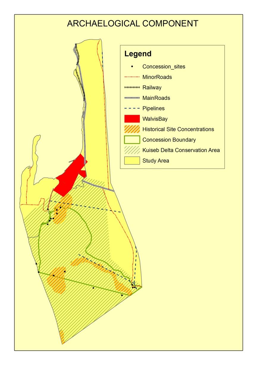
Figure 5.1 Archaeological Setting
The study area has been a traditional range for the Topnaars ("strandlopers") leading a
nomadic lifestyle as hunters and gatherers. However, this range was dramatically
reduced by the proclamations of Namib Naukluft and Skeleton Coast National Parks
forcing the Topnaars to become permanent settlers. Currently, the Topnaars are
marginalized and have only begun to earn income from tourism. They have become a
significant part of cultural tourism in Namibia for their donkey carts and cultural
performances. A number of operators include visits to the Topnaars in their
itineraries. The recent proclamation of community concessions by the Ministry of
Environment & Tourism (MET), on which they can earn income from tourism and lead life
as a coherent cultural group, holds opportunities to uplift their standard of living (Nyakunu
and Ndlovu, 2010).
The Dune belt is a coherent 3-4 km wide zone of relatively high dunes extending along
the 25 km stretch of coastline from Walvis Bay to Swakopmund. The western boundary of
the dune area lies approximately 500 m from the seashore (Skov et al, 2007). This
coastal "dune belt area" between Swakopmund and Walvis Bay is characterized by
unique biodiversity and conservation thereof imperative for Namibia‟s biodiversity
heritage and sustainable tourism along the coast. The area between the two towns is also
part of the newly proclaimed Dorob National Park. However, some areas are set aside for
Off-Road Vehicle use for recreational purposes. The area is also frequented by seasonal
recreational tourists from inland and abroad, particularly from South Africa. These
seasonal or summer recreational tourists practice several leisure activities such as line
fishing, water and motor sports, sand boarding, paragliding/sailing, ballooning, and off-
road adventures. The use of ORVs, in particular quad-bikes as a hobby and outdoor
activity, throughout the year and during peak holiday seasons continues to cause a
nuisance to the environment. The NACOMA project through line ministries has drafted
draft regulations specific to the Dorob National Park under the Nature Conservation
Ordinance No. 4 of 1975 including the Dune Belt area. Several resolutions and proposals
have been approved including zonation plans, proclamation of Dorob National Park and
off-road vehicles moratorium (Skov, 2007).
5.6 Socioeconomic Environment of the Erongo Region
This section provides a brief introduction on the socio-economic characteristics of the
Dorob National Park area for scoping purposes. The information gathered from the
literature is based on Erongo Region demographic data. The detailed review of the
socio-economic environment for the Kuiseb Delta & Dune Belt Area will be finalised
during the EIA. The aim for this review is to identify social and economic trends and
anticipate the potential impacts of the proposed community-based tourism project‟s on
the overall well-being of the region‟s population in general and the Topnaars community
According to NPC (2007), only 0.4% of households in the Erongo Region spend more
than 80% of their income on food while 5.3% of households spend 60 – 79% of their
income on food. The adjusted per capita income (adjusted for household composition) in
the Khomas Region is the highest in the country and set at N$ 25 427 per annum, while
Erongo has the second highest per capita income of N$ 16 819 per annum. Therefore,
Erongo is one of most affluent regions in Namibia (NPC, 2007).
Walvis Bay is located within the web of coastal transportation, communication and utility
systems and networks. The following is the summary of the socio-economic and
infrastructural settings of the Dorob National Park‟s Coastal areas and Erongo Region:
Governance: The regional capital of the Erongo Region is Walvis Bay and the
region has a total area of 63 586 km 2;
Population: Based on 2001 census the region has a total population of 107 663
with 85% of the population living in urban areas;
Industries: Major industries are fisheries, tourism, services, mining and
Air: International air connections for both passengers and freight are available at
Windhoek‟s Hosea Kutako International Airport to Walvis Bay. Walvis Bay
International Airport is located about 10 km from Walvis Bay and the airport has
regular flights to Cape Town, Johannesburg and Windhoek. Direct destinations
include the strategic regional hub of Johannesburg, and the European cities of
London and Frankfurt. Air Namibia is the national carrier and other international
airlines operating in the country are South African Airways, British Airways/Comair,
TAAG and LTU. There are also direct flights between Windhoek and Luanda,
Lusaka, Harare, Livingstone and Cape Town, as well as domestic flights to local
destinations from the Windhoek‟s Eros Airport.
Sea: As an Operations Base, Walvis Bay, with its world-class standard of cargo
handling and sheltered deepwater harbour, is poised to become the most
important port on Africa‟s west coast and a regional container hub for southern
Africa. The completion in 2000, of the deepening process and the building of a new
enlarged container terminal able to handle vessels with a capacity of some 2000 to
2400 TEUs (Twenty-foot equivalent unit, a measure used for capacity in container
transportation) put the port on a par with Cape Town and Durban. Container
vessels from Europe can save three days‟ journey time by loading and/unloading
in Walvis Bay, rather than Cape Town, while cargoes for central and Southern
Africa from elsewhere in the Atlantic region can gain up to seven days by using
Walvis Bay and going further overland.
The dedicated facilities for a range of commodities, including containerised cargo,
refrigerated produce, break bulk, dry bulks, and petroleum products. The port
currently handles around 2.5 million tons of cargo annually, with an average
turnaround time of about 12-18 hours for container vessels. Products include
foodstuffs, marble blocks, lead and copper ingots and an annual 500,000 tons of
salt. As well as excellent logistical support services, there is a thriving ship repair
and marine engineering industry at Walvis Bay. Walvis Bay Port is administered by
the Namibian Ports Authority (NamPort), a state owned organization established in
1994, part of whose role is to ensure the smooth operation of cross-border trade.
The ports enjoy good industrial relations, with well-motivated workforces, and are
able to offer a high standard of stevedoring to complement their modern dockside
Road: Walvis Bay is well linked to the developed road network covering more than
40,000 kilometres and providing access to the majority of towns in Namibia. The
primary route the B2 connecting Walvis Bay and Swakopmund is tarred and link to
the Trans-Caprivi Highway which provides an all weather road link between Walvis
Bay and Botswana, Zambia and Zimbabwe, as well as the Democratic Republic of
Congo. The Trans-Kalahari Highway links Walvis Bay with South Africa‟s Gauteng
industrial heartland via Botswana. Previously this region used Durban as its natural
gateway. The highway is also connected to the Maputo Corridor on Africa‟s east
coast, thus providing a transport link across the entire breadth of the continent;
Rail: A national network of railways covering 2, 382 kilometres connects Walvis
Bay and Lüderitz with key destinations in Namibia and South Africa. Much of the
containerized traffic at Walvis Bay goes by rail, and the port has its own
marshalling yard for maximum operational efficiency. Thousands of tons of bulk
minerals from mines in South Africa and Namibia are transported directly to the
quayside by rail for export;
Walvis Bay Corridor: The Walvis Bay Corridor is the name for a newly
constructed network of transport which has opened up access to landlocked
southern Africa for destinations west of the continent by the shortest possible
route. Completed in 1998, and using the port of Walvis Bay as the trade gateway,
its main arteries are the Trans-Caprivi and Trans-Kalahari Highways. The Walvis
Bay to Grootfontein railway line also forms part of the corridor;
Telecommunications: Walvis Bay and Swakopmund are some of the few towns
in Namibia that enjoys world class telecommunications system, with telephone and
internet connections widely available, thanks to recent substantial investment in
the telecommunications infrastructure including the installation of optical fibre cable
networks and broadband systems. An international satellite links Namibia to
worldwide telecommunications services. A GSM900 network is operated by Mobile
Telecommunications LTD (MTC), Namibia first cellular service provider. About 80
per cent of the population is within reach of this network. MTC currently has
roaming agreements with 160 countries worldwide, and visitors from these
countries can use their GSM900 phones in Namibia without difficulty;
Business Services: The full range of business support services is available in
Walvis Bay, including banking and finance, insurance, stock broking, accountancy,
general business consultancy, advertising and marketing agencies and conference
facilities. The Country has a well-established banking system. The Bank of
Namibia is responsible for issuing currency and is the foreign exchange authority,
lender of last resort to banking institutions, banker to the Government and the
commercial banks and the supervisory authority on financial institutions and
monetary matters. Commercial banks operate through a nationwide network of
branches and offer a comprehensive range of banking services, including current
account and overdraft facilities, term deposits, discounting of bills, foreign
exchange and a variety of loan products.
The major banks also represented in Walvis Bay are Bank Windhoek Ltd., the
Nedbank Bank of Namibia Ltd., First National Bank of Namibia and Standard Bank
of Namibia Ltd. Most also provide specialised merchant banking facilities.
International services are available through inter-bank arrangements. Electronic
banking and teller services are available in Walvis Bay and all major centres in
Namibia. The Namibian Dollar (N$) is divided into 100 cents. It is linked to and on
a par with the South African Rand (R) which is also legal tender in Namibia. The
Namibian Stock Exchange is Africa‟s second largest in terms of total market
capitalization and among the continent‟s most technically advanced bourses;
Energy: There is a 66 kV power line linking Walvis Bay and Swakopmund.
NamPower which has restructured and repositioned itself to address the
challenges of a restructured Namibian electricity supply industry is actively
pursuing all avenues for increasing electricity generation capacity in the country.
The main sources of power are the thermal, coal-fired Van Eck power station
outside Windhoek (120 megawatts), the hydroelectric plant at Ruacana Falls (240
megawatts), the diesel driven Paratus power station at Walvis Bay (24 megawatts)
and one interconnecting line from Eskom (South Africa) (200 megawatts). To meet
the growing power demand, NamPower commissioned the construction of the 900-
kilometer, 400kV interconnector power line from Kenhardt in South Africa to Auas
near Windhoek in 2000. In terms of the availability of fuels to run the project in the
area, the country has a well-established downstream oil marketing infrastructure
that is closely linked with South Africa. There are five main companies distributing
and marketing fuel products in Namibia.
5.7 Geological Settings
5.7.1 Geomorphology
The study area is characterized by four distinct geomorphological units. The largest by far
the is dune field. Other units include inter-dune plains, gravel / coastal plain, river beds
and delta, as well as gently undulating plains dotted with rock outcrops.
From the south, the study area cut across the sand sea of the southern Namib. The
eastern section of this area has longitudinal dunes, oriented north-south, and
approximately a kilometre apart. They grades into transverse dunes some 8 km from the
coast and as the Kuiseb Delta begin to form. These dunes have their slipface oriented
mainly to the north, hence providing comparatively favourable climatic conditions for
supporting selected desert dwelling fauna or flora and also sheltered from the strong
winds blowing predominantly from the south (Figure 5.2). Whereas transverse and
barchans dunes cut across the Kuiseb Delta, longitudinal dunes came to a halt at the
Kuiseb River. The Kuiseb Delta is up to approximately 15 km wide at the apex (Figure
5.2). It is characterized by a variety of vegetation, including reeds. This betrays a high
water table. Dune hummocks occur in the immediate surroundings of the delta.
Transverse and barchans dunes constitute the dune system between Walvis Bay and
Swakopmund. Like the dune system south of the Kuiseb River, interdunal plains occur in
this unit. Judging from historical data, bases of dunes are generally stable. Common
features in the interdune and gravel / coastal planes are patches of vegetated hummocks
(Hipondoka, 2011).
Figure 5.2 Morphology Map
5.7.2 Topography
The proposed study area is highly characterised by sand dunes of the central Namib
Sand Sea, which form a narrow coastal belt between Walvis Bay and Swakopmund. On
the other hand the area is made up of undulating gravel plains which are seasonally used
by the damara tern as breeding areas.
5.7.3 Regional Geology
Regionally, Walvis Bay falls within the Central Zone of the Damara Sequence which
underlies most of Central Namibia. The oldest rocks within the Central Zone are the pre-
Damaran basement that consists of gneiss and granite lithologies found in different parts
of the zone. According to Miller, (1983), the Sequence was deposited during successive
phases of rifting, spreading, subduction and continental collision. Much of the basal
succession (Nosib Group), laid down in or marginal to intracontinental rifts, consists of
quartzite, arkose, conglomerate, phyllite, calc-silicate, subordinate, limestone and
evaporitic rocks. Local alkaline ignimbrites with associated subvolcanic intrusions ranging
from 840 to 720 million years in age also form part of the regional geology (Miller, 1992).
According to Miller, (1992), widespread carbonate deposition followed and overlapped far
beyond early rift shoulders (Kudis, Ugab and basal Khomas Subgroups); interbedded
mica and graphitic schist, quartzite (some ferruginous), mass flow deposits, iron-
formation and local within-plate basic lava point to fairly variable depositional conditions
south of a stable platform where only carbonates with very minor clastics occur (Otavi
Group). Near the southern margin of the orogen, deep-water fans, facies equivalents of
the carbonates were deposited on either side of a Southern Zone ocean separating
Kalahari and Congo Cratons (Auas and Tinkas Formations). Thick schistose
metagreywacke and metapelite (Kuiseb Formation) overlie the above rocks.
5.7.4 Local Geology
Locally the Walvis Bay area is underlain mainly by biotite schists, quartzites, meta-
greywackes, marbles and calc silicates of the Tinkas member of the Karibib Formation,
Swakop Group of the Damara. These rocks have been intensely isoclinally folded and
locally have a NNE/SSW strike. Dips are generally steep and Salem-type granites and
pegmatites have intruded the area, mainly in the West. Karoo-age dolerite dykes intrude
the Damara metasediments and trend parallel to the foliation. Surficial sediments of
Tertiary to Recent age have been deposited over large parts of the whole of Walvis Bay
area, mainly confined to present and paleodrainage features (Ransom, 1981).
The calcareous grit is found around Walvis Bay area comprise relatively of mature
sediment containing clasts largely consisting of rounded to subangular quartz and
feldspar grains cemented by calcium carbonate. Clasts of Damara metasediments and
Karoo dolerite are rarely present. The calcareous grit is preliminarily regarded as the
oldest of the surficial sedimentary succession and fills an old paleodrainage feature
through which the main present-day Tumas drainage cuts (Ransom, 1981; Bortom, and
Ransoh, 1980; Bortom, 1977).
According to Ransom (1981), Bortom and Ransoh (1980) and Bortom, (1977), the other
type of surficial deposits found in the Walvis Bay area in general, is the brown calcareous
siltstone which is far more immature than the calcareous grit and contains more angular
fragments and a higher percentage of mafic minerals. The cement is calcium carbonate
and its brown colouration is due to the weathering of mafic minerals. Although it is
considered to be younger it is often in direct contact with the basement schist due to
overlapping on the edges of minor basins and paleochannels (Ransom, 1981).
The youngest of the surficial sediments is the formation of gypsum which occurs as
fibrous veins and as cement to the recent sands, river gravels, and sedimentary breccias.
The gypsum appears to be forming at present as a result of the common sulphurous
mists blowing off the sea and reacting with the calcareous sediments to form gypsum as
a replacement of calcite.
5.7.6 Soils
The soils of the Namib Desert are formed by various processes, both mechanical and
chemical. Soils along the coastal parameters have a high concentration of salts and
hydrogen sulphide, which has an influence on the fog and in return intensifies chemical
procesesses and soil genesis. Closer to the coast, soils are more likely to be consisting of
gypsum while soils further inland are characterised by concrete surfaces. (Christian,
5.7.7 Water
The study area lies within the most arid part of the country were the mean annual rainfall
is less than 50mm per annum. However, due to the good geological setting as well as the
presence of the alluvial aquifers in the Omaruru and Kuiseb Rivers that extend into high
rainfall catchment areas, sufficient good quality groundwater is available for different land
users in the coastal towns through the water supply scheme (InnoWind Draft Scoping
Baseline Report, 2010), (Christian, 2006) and (Heyns et al, 2009) and (Ninham Shand
Consulting Services, 2008).
ENVIRONMENTAL MANAGEMENT
6.1 Overview
The NACOMA PCO requested that the EIA and EMP for the proposed KDDT and Walvis
Bay Bird Paradise community-based activities be compliant with the National regulations.
Namibia‟s Environmental Policy for Sustainable Development and Environmental
Conservation (1995) requires that all listed policies, programmes and projects whether
initiated by government or the private sector be subjected to an SEA or EIA. The purpose
of this policy is seen as: informing decision makers and promoting accountability;
ensuring that opinions and alternatives and environmental costs and benefits are
considered; striving for a high degree of public participation and involvement of all
sectors; incorporating internationally accepted norms and standards; taking into account
secondary and cumulative environmental impacts; promoting the user pays principle; and
promoting sustainable development.
The Environmental Management Act although not yet implemented provide legal
framework for EIA and gives legislative effect to the EIA Policy referred to in the previous
6.2 Namibia Environmental Assessment Procedure
Namibia‟s Environmntal Assessment Policy for Sustainable Development and
Environmental Conservation (1995) as well as the Draft Procedures and guidelines for
EIA & EMP of 2008 requires the following steps in an Environmental Impact Assessment
Procedure (See Figure 1.2):
1. Project Concept / Identification
2. Appoint an Environmental Practitioner
3. Development of Proposal through consultation
4. Application with Baseline Report and Draft Environmental Management Plan for no
Formal EIA Process
5. Notification with Baseline Report and Terms of Reference for full EIA
6. Review of Applications / Registrations
7. Full investigation, EIA Report and Draft Environmental Management
8. Plan (Mitigation Plan)
9. Application with Full EIA and Draft Environmental Management Plan
10. Conditions and Approval
11. Record of Decisions
13. Implementation of proposal
14. Monitoring, auditing and ongoing mitigations
Environmental Management Act 7 of 2007 stress that the twelve principles of
environmental management (Part II, Section 3 of Act) should be applied to all projects
that may impact on the environment:
Use renewable resources on a sustainable basis for the benefit of present and
future generations
Involve community in natural resources management and promote and facilitate
the sharing of benefits from the use of resources
Promote Public participation in decisions affecting the environment and ensure that
their interests, needs and values are taken into account
Promote equitable access to environmental resources and consider the functional
integrity of ecological systems to ensure the sustainability of the systems and to
prevent harmful effects
Undertake assessments for activities which may have significant effects on the
environment or the use of natural resources
Promote sustainable development in all aspects relating to the environment; Protect and respect Namibia‟s cultural and natural heritage including, its biological
diversity for the benefit of present and future generations
Reduce the generation of waste and polluting substances at source by adopting
the option that provides the most benefit or cause the least environmental damage,
at cost acceptable by society, in the short and long term
Promote the reduction, re-use and recycling of waste Adopt the "polluter pays principle" In cases where there is sufficient evidence which establishes that there are threats
of serious or irreversible damage to the environment, lack of full scientific certainty
may not be used as a reason for postponing cost-effective measures to prevent
environmental degradation
Prevent damage to the environment and reduce activities which cause such
damage limited or controlled.
6.3 Compliance to National and International Requirements
The proposed projects received Matching Grants through NACOMA from the World Bank.
Therefore these projects are required as per World Bank requirements to be subjected to
an EIA. Moreover, According to the Namibia‟s EIA procedures the following activities
need to take place:
Submission of Project Proposal Registration of the Project with DEA/MET Development of Proposal and Classification of Proposal
The KDDT and Walvis Bay Bird Paradise will be subjected to the full EIA as their activities
fall in the category listed in the Draft Procedures and Guidelines for EIA and EMP "Land
use planning and development activities".
CONCLUSIONS AND RECOMMENDATIONS
7.1 Scoping Study Conclusions
Coastal tourism is a priority economic area for local, regional and national development
(NACOMA, 2007). Community-based tourism activities can provide employment but they
are also likely to cause social and environmental impact. Biological hotspots, breeding
areas, environmental sensitive areas may suffer from uncontrolled tourism development
and activities. These impacts however can be effectively mitigated through careful
planning and design of sustainable tourism activities.
The likely constraints that may be associated with tourism activities in the study area are:
- Existing tourism infrastructure and the construction processes of tourism structures
- Conflicting overlay activities competing with tourism over similar geographic area.
Such conflict may occur between tourism and conservation, farming and mining.
- The surrounding Namib Desert Sand Dunes
- Local biodiversity
- Visual effects especially waste and pollution
- Others to be identified during consultation with full EIA Process to be undertaken
7.2. Scoping Study Recommendations
7.2.1 Full Environmental Assessment
Based on the findings of the scoping study it is recommended that a full EIA and the
development of an EMP be undertaken for the proposed eco-tourism and recreational
activities in the Kuiseb Delta and Dune Belt area. Draft TOR for the full EIA and EMP
include the list of stakeholders, specialist studies to be undertaken, likely positive and
negative impacts to be considered as well as draft proposed outline of the EIA and EMP
7.2.2 Aims and Objectives of the Full Environmental Assessment (EA)
The aims and objectives of the full EIA and EMP with respect to the proposed eco-
tourism activities in the Kuiseb and Dune Belt areas are:
To assess all likely positive and negative impacts environmental and social
impacts on the local and regional (Erongo Region) and national (Namibia) using
appropriate assessments guidelines, methods and techniques covering the
complete project cycle. The EIA and EMP shall be performed in accordance and
conforming to national regulatory requirements, process and specifications in
Namibia and in particular Ministry of Environment and Tourism and the Namibian
Tourism Board as well as draft guidelines for conducting EIA & EMP (MET/DEA,
The development of appropriate mitigation of appropriate measures that will
enhance the positive impacts and reduce the likely negative impacts anticipated or
7.2.3 Stakeholders
Stakeholders‟ participation in the EIA process is a critical component in achieving
transparent decision-making. Stakeholders‟ involvement in the EIA process gives all
interested and affected parties such as local communities and individuals a voice in
issues that may bear directly on their health, welfare, and quality of life. An open flow of
environmental information can foster objective consideration of the full range of issues
involved in project planning and can allow communities and citizens to make reasoned
choices about the benefits and risks of proposed actions (DEA, 20008).
A number of interviews and workshops will be conducted with the members of the local
communities and any other stakeholders particularly in Walvis Bay and Institutions from
Swakopmund and Walvis Bay. Consultations with stakeholders will cover the following:
- Awareness about the proposed projects
- Expectations of local communities in terms of temporal and permanent
contracts/job opportunities as well as local economic benefits
- Worries and concerns of farmers and existing tour operators in Kuiseb Delta and
- Views of the various stakeholders, particularly the local communities of Walvis
Bay, with respect to the likely positive and negative impacts of the proposed
project on the environment and suggestions on the appropriate mitigation
The following is the provisional list of identified interested and affected stakeholders who
will be contacted for input/comments to the EIA process:
- MET/DEA/NACOMA
- MET – Parks, CBNRM, Tourism
- Roads Authority
- Ministry of Fisheries and Marine Resources (NATMIRC)
- Ministry of Regional Local Government Housing and Rural Development
- Erongo Regional Council
- Namibia Wildlife Resorts
- Namibia Tourism Boards
- KDDT and Boards of Trustees
- Topnaars community in the Kuiseb Delta
- Walvis Bay Bird Paradise Caretaker
- Traditional authority
- Coastal Tour Operators Association
- Coastal Environment Trust of Namibia
- Lauberville – in the Kuiseb Delta
- National Heritage Council of Namibia
- Fishing Companies and NamPort (those involved with Topnaars community)
- 18 Tour operators and agencies are identified (Having stake in the KDDT)
- Rossing Foundation/Rio Tinto
- NGOMA Consulting Services
- Local and Tour Operator Organisations and representatives
- Walvis Bay Municipality
- Ministry of Agriculture, Water and Forestry
- National Botanical Research Institute
- Other stakeholders to be identified during newspaper advertisement and to be
registered and reflected in the Final EIA report
7.2.4 Specialist Studies to be Undertaken
The specialist studies identified during scoping will be undertaken by specialist
consultants and the results of these studies will comprise the full EIA and EMP reports.
The Archaeology study
The Vertebrate Fauna and Flora study
Geomorphology study
7.2.5 Likely Positive Impacts to be Considered
The following is the summary of the likely positive impacts that will be assessed at
different levels of the current and proposed tourism developmental stages;
Local and Regional social, economic, and cultural impacts;
Opportunities for community participation;
Other issues to be identified during the consultation process.
7.2.6 Likely Negative Impacts to be Considered
The following is the summary of the likely negative impacts that will be assessed at
different levels of the existing and proposed tourism activities in the area;
Current and future land uses, zonation and existing infrastructures and
Threats to biodiversity (habitat alteration and species injury or mortality and
Visual impacts, Water use and quality;
Waste and Sewage management at project sites ;
Wind situation; Tourism activities and quad-biking
Other issues to be identified during the consultation and full Environmental
Assessment process.
7.2.7 Environmental Management Plan (EMP) Considerations
The following is the summary of the likely EMP considerations that will be assessed
based on the findings of the EIA:
- Waste and sewerage management
- Wind situation
- Tourism Carrying Capacity
- Facilities and structures at Project sites
- Historic and Archaeology sites
- Implementation of the EMP
- Environmental Awareness and Training
- Off-road Vehicle zones, access and driving
- Tour activities (e.g. hiking and driving trials, archaeology, historical and cultural
- Dealing with Environmental Complaints Guidance
7.2.8 Proposed Outline of EIA and EMP Reports
The following is the summary of the tentative content lists of EIA, EMP and Final Scoping
(Baseline) reports:
VOLUME 1 or Part 1: Environmental Impact Assessment (EIA)
EXECUTIVE SUMMARY
(xiii) PROJECT BACKGROUND
(xiv) POLICY, LEGAL, AND ADMINISTRATIVE FRAMEWORK
DETAILED PROJECT DESCRIPTION
(xvi) SOCIO-ECONOMIC ENVIRONMENT
(xvii) METHODOLOGY
(xviii) NATURAL ENVIRONMENTS
(xix) ASSESSMENT OF LIKELY ENVIRONMENTAL IMPACTS
ANALYSIS OF ALTERNATIVES
(xxi) EIA CONCLUSIONS AND RECOMMENDATIONS
(xxii) REFERENCES
VOLUME 2 OR PART 2: ENVIRONMENTAL MANAGEMENT PLAN (EMP)
INTRODUCTION TO THE EMP
ENVIRONMENTAL POLICIES
OBJECTIVES OF THE EMP
(xiii) THE EMP FRAMEWORK
(xiv) IMPLEMENTATION OF THE EMP
ENVIRONMENTAL MONITORING PLAN
(xvi) ENVIRONMENTAL MANAGEMENT AND TRAINING
(xvii) APPENDICES
(xviii) REFERENCES
VOLUME 3 OR PART 3: FINAL SCOPING REPORT
EXECUTIVE SUMMARY
PROJECT BACKGROUND
ENVIRONMENTAL REGULATORY FRAMEWORK
DESCRIPTION OF PROPOSED PROJECTS
BASELINE ENVIRONMENT
HERITAGE RESOURCES
SOCIO-ECONOMIC ENVIRONMENT
(viii) GEOLOGICAL SETTINGS
ENVIRONMENTAL MANAGEMENT
CONCLUSIONS AND RECOMMENDATIONS
REFERENCES
Alexander, G. and Marais, J. 2007. A guide to the reptiles of southern Africa. Struik Publishers, Cape Town, RSA. Barnard, P. 1998. Underprotected habitats. In: Barnard, P. (ed.). Biological diversity in Namibia: a country study. Windhoek: Namibian National Biodiversity Task Force. Bester, B. 1996. Bush encroachment – A thorny problem. Namibia Environment 1: 175-177. Bethune, S., Shaw, D. and Roberts, K.S. 2007. Wetlands of Namibia. John Meinert Printing, Windhoek. Bortom, D. 1977. Interim Report on the Tumas Project-Prospecting Grant Number M46/3/738 (Namib Desert Park, S.W.A), Falconbridge of S.W.A (P.T.Y) LTD, Bulletin No. January, 1977 (Annex 1). Bortom, D., & Ransoh, A.H. 1980. Interim Report on the Tumas Project Prospecting Grant Number M46/3/738 (Namib Desert Park, S.W.A) Falconbridge of S.W.A (P.T.Y) LTD, Bulletin No. September, 1980 (Annex 3). Boycott, R.C. and Bourquin, O. 2000. The Southern African Tortoise Book. O Bourquin, Hilton, RSA. Braby, J, 2011. The Biology and conservation of the Damara Tern in Namibia. PhD thesis, University of Cape Town, RSA. Braby, J. 2010a. New migration records for the Damara Tern Sterna balaenerum. Ornithological Observations 1: 38-41. Braby, J. 2010b. The Damara Tern: What we know and what we don‟t. Unpublished Report, NACOMA, Swakopmund, Namibia. Braby, J. and Braby, N. 2002. Report on daily observations at the breeding colony of Damara terns Sterna balaenarum south of Swakopmund in the gravel plains surrounding the horses‟ grave yards during the 2001/2 season. Unpublished report, MET, Swakopmund. Braby, R., Shapira, A. and Simmins, R.E. 2001. Successful conservation measures and new breeding records for Damara terns Sterna balaenarum in Namibia. Marine Ornithology 29(2): 81-84. Branch, B. 1998. Field guide to snakes and other reptiles of southern Africa. Struik Publishers, Cape Town, RSA. Branch, B. 2008. Tortoises, terrapins and turtles of Africa. Struik Publishers, Cape Town, RSA. Broadley, D.G. 1983. Fitzsimons‟ Snakes of southern Africa. Jonathan Ball and AD. Donker Publishers, Parklands, RSA.
Brown, C.J., Jarvis, A., Robertson, T. and Simmons, R. 1998. Bird diversity. In: Barnard, P. (ed.). Biological diversity in Namibia: a country study. Windhoek: Namibian National Biodiversity Task Force. Bundesanstalt für Geowissenschaften und Rohstoffe (BGR) and Geological Survey of Namibia (GSN). 2008. Strategic Environmental, Social and Economic Assessment for the Central Namib Uranium Rush Bundesanstalt für Geowissenschaften und Rohstoffe (BGR) and Geological Survey of Namibia (GSN). 2008. Strategic Environmental, Social and Economic Assessment for the Central Namib Uranium Rush. Burke, A. 1998. Vegetation zones. In: Barnard, P. (ed.). Biological diversity in Namibia: a country study. Windhoek: Namibian National Biodiversity Task Force. Burke, A. 2003. Wild flowers of the Central Namib. Namibia Scientific Society, Windhoek. Buys, P.J. and Buys, P.J.C. 1983. Snakes of Namibia. Gamsberg Macmillan Publishers, Windhoek, Namibia. Carruthers, V.C. 2001. Frogs and frogging in southern Africa. Struik Publishers, Cape Town, RSA. Channing, A. 2001. Amphibians of Central and Southern Africa. Protea Bookhouse, Pretoria, RSA. Channing, A. and Griffin, M. 1993. An annotated checklist of the frogs of Namibia. Madoqua 18(2): 101-116. Christian, C. 2006. Environmental impact assessment and environmental management plan for the exploration. Colin Christian and Associates Report, No. C002. Windhoek, Namibia. Coats Palgrave, K. 1983. Trees of Southern Africa. Struik Publishers, Cape Town, RSA. Craven, P. 1998. Lichen diversity in Namibia. In: Barnard, P. (ed.). Biological diversity in Namibia: a country study. Windhoek: Namibian National Biodiversity Task Force. Craven, P. (ed.). 1999. A checklist of Namibian plant species. Southern African Botanical Diversity Network Report No. 7, SABONET, Windhoek. Craven, P. and Marais, C. 1986. Namib Flora. Gamsberg Macmillan Publishers, Windhoek. Crawford, R.J.M., Simmons, R.E. 1997. Damara Tern Sterna baleanarum. In: Harrison, J., Allan, D.G., Underhill, L.G., Herremans, M., Tree, A.J., Brown, C.J. (Eds). The atlas of southern African birds. Vol 1: Non-passerines. Johannesburg: BirdLife South Africa pp 480–481. Crawford, R.J.M., Dyer, B.M., Kemper, J., Simmons, R.E. and Upfold, L. 2007. Trends in numbers of Cape Cormorants (Phalacrocorax capensis) over a 50-year period, 1956-57 to 2006-07. Emu 107: 253 261.
Cunningham, P. 2011. Biophysical Assessment (Vertebrate Fauna and Flora) associated with the Kuiseb Delta and Dune Belt area. Environment and Wildlife Consulting, Namibia. Cunningham, P.L. 2006. A Guide to the Tortoises of Namibia. Polytechnic of Namibia, Windhoek. Curtis, B. and Barnard, P. 1998. Sites and species of biological, economic or archaeological importance. In: Barnard, P. (ed.). Biological diversity in Namibia: a country study. Windhoek: Namibian National Biodiversity Task Force. Curtis, B. and Mannheimer, C. 2005. Tree Atlas of Namibia. National Botanical Research Institute, Windhoek, Namibia. De Graaff, G. 1981. The rodents of southern Africa. Buterworths, RSA. De Lukas, M, Janss, G.F.E., Whitfield, D.P. and Ferrer, M. 2008. Collision fatality of raptors in wind farms does not depend on raptor abundance. Journal of Applied Ecology 45(6): 1695-1703. Du Preez, L. and Carruthers, V. 2009. A complete guide to the frogs of southern Africa. Struik Publishers, Cape Town, RSA. Estes, R.D. 1995. The behaviour guide to African mammals. Russel Friedman Books, Halfway House, RSA. Garthe, S. and Hüppop, O. 2004. Scaling possible adverse effects of marine windfarms on seabirds: developing and applying a vulnerability index. Journal of Applied Ecology 41(4): 724-734. Giess, W. 1971. A preliminary vegetation map of South West Africa. Dinteria 4: 1 – 114. Griffin, M. 1998a. Reptile diversity. In: Barnard, P. (ed.). Biological diversity in Namibia: a country study. Windhoek: Namibian National Biodiversity Task Force. Griffin, M. 1998b. Amphibian diversity. In: Barnard, P. (ed.). Biological diversity in Namibia: a country study. Windhoek: Namibian National Biodiversity Task Force.
Griffin, M. 1998c. Mammal diversity. In: Barnard, P. (ed.). Biological diversity in Namibia: a country study. Windhoek: Namibian National Biodiversity Task Force.
Griffin, M. 2003. Annotated checklist and provisional national conservation status of
Namibian reptiles. Ministry of Environment and Tourism, Windhoek.
Griffin, M. 2005. Annotated checklist and provisional national conservation status of
Namibian mammals. Ministry of Environment and Tourism, Windhoek.
Hamukwaya, F. and Cunningham, P.L. 2007. Some notes on the breeding of the Crowned Cormorant, Phalacrocorax coronatus, from Bird Rock, Namibia. Lanioturdus 40(1): 6-8. Hebbard, S. n.d. A close-up view of the Namib and some of its fascinating reptiles. ST Promotions,Swakopmund, Namibia. Hipondoka, M.H., 2011. Geomorphology Report. University of Namibia, Windhoek. http://www.walvisbay-eco-tourism.com Hockey, P.A.R., Dean, W.R.J. and Ryan, P.G. 2006. Roberts Birds of Southern Africa VII Edition. John Voelcker Bird Book Fund. InnoWind Energy Namibia. 2010. Draft Scoping (Baseline) Report for the proposed 60 MW Multiphase Wind Energy Project on Farm 37, Walvis Bay Erongo Region, Namibia. IUCN, 2010. IUCN Red List of Threatened Species. IUCN, Gland, Switserland. Jacobson, P.J., Jacobson, K.M., and Seely, M.K. 1995. Ephemeral rivers and their catchments: sustaining people and development in western Namibia. Desert Research Foundation of Namibia, Windhoek. Joubert, E. and Mostert, P.M.K. 1975. Distribution patterns and status of some mammals in South West Africa. Madoqua 9(1): 5-44. Kinahan J & Kinahan J, 2008, Kuiseb Basin archeological baseline study. GTZ (unpublished) Kolberg, H. n.d. Preliminary Inventory of Namibia‟s Wetlands. Directorate Scientific Services, Ministry of Environment and Tourism, Windhoek, Namibia. Kolberg, H. 2010. Summary of the summer 2010 wetland bird counts in Namibia. Lanioturdus 43(4): 13. Komen, L. n.d. The Owls of Namibia – Identification and General Information. NARREC, Windhoek. Lovegrove, B. 1999. The living deserts of southern Africa. Fernwood Press, Vlaeberg, RSA. Maclean, G.L. 1985. Robert‟s birds of southern Africa. John Voelcker Bird Book Fund. Maggs, G. 1998. Plant diversity in Namibia. In: Barnard, P. (ed.). Biological diversity in Namibia: a country study. Windhoek: Namibian National Biodiversity Task Force. Mannheimer, C. and Jacobson, K. 1998. Fungal diversity in Namibia. In: Barnard, P. (ed.). Biological diversity in Namibia: a country study. Windhoek: Namibian National Biodiversity Task Force. Mannheimer, C. and Curtis, B. 2009. Le Roux and Müller‟s field guide to the trees and shrubs of Namibia. Macmillan Education, Windhoek.
Marais, J. 1992. A complete guide to the snakes of southern Africa. Southern Book Publishers, Witwatersrand University Press, Johannesburg, RSA. Mendelsohn, J., Jarvis, A., Roberts, C. and Robertson, T. 2004. Atlas of Namibia – a portrait of the land and its people. David Philip Publishers, Cape Town. Mendelsohn, J., Jarvis, A., Roberts, A., and Robertson, T. 2002. Atlas of Namibia: a portrait of the land and its people. David Philip Publishers, Cape Town, South Africa. Monadjem, A., Taylor, P.J., F.P.D. Cotterill and M.C. Schoeman. 2010. Bats of southern and central Africa. Wits University press, Johannesburg, RSA. Miller RM. 1983. The Pan-African Damara Oregon od S.W.A/Namibia, SpecialPublication of the Geological Society of South Africa, 11, 431-515. Miller, RM. 1992. Stratigraphy. The mineral resource of Namibia, Geological Survey of Namibia, Ministry of Mines and Energy, Windhoek, 1.2.1-1.2.13 Müller, M.A.N. 1984. Grasses of South West Africa/Namibia. John Meinert Publishers (Pty) Ltd, Windhoek, Namibia. Müller, M.A.N. 2007. Grasses of Namibia. John Meinert Publishers (Pty) Ltd, Windhoek, Namibia. NACOMA. 2009. Management and development plan for the Central Coast Park of the Namib-Skeleton Coast National Park. Ministry of Environment and Tourism, Directorate of Environmental Affairs. Windhoek NACOMA. 2007. Sustainable tourism options for the coastal zone and refinement of baseline tourism data. Ministry of Environment and Tourism. Directorate of Environmental Affairs, Windhoek. NACOMA. 2004. Rapid Assessment of the development plans, biodiversity conservation projects and socio-economic situation of the Namib Coastal Regions. Ministry of Environment and Tourism, Directorate of Environmental Affairs. Windhoek NACSO, 2010. Namibia‟s communal conservancies: a review of progress and challenges in 2009. NACSO, Windhoek. National Planning Commission. 2007. „Erongo regional poverty profile, main report‟. Windhoek: National Planning Commission. Nyakunu, F and Ndlovu, J. 2010. Kuiseb Delta Development Project Feasibility Study and Business Plan. Polytechnic of Namibia. Consultancy prepared for NACOMA, Ministry of Environment and Tourism. Passmore, N.I. and Carruthers, V.C. 1995. South African Frogs - A complete guide. Southern Book Publishers, Witwatersrand University Press, Johannesburg, RSA. Ransom, A.H. 1981. Interim Report on Prospecting Grant No. M46/3/758-Tuma Project No. 53-Namiba Desert Park – Namibia, Period April 1978 – April 1981, Falconbridge of S.W.A (P.T.Y) LTD, Bulletin No. 2267 (Annex 4).
Reptile Uranium Namibia. 2010. Scoping Report for the Omahola Project. Report No RUNSCOREP/2010/01
Republic of Namibia. 1995. Namibia‟s Environmental Assessment Policy. DEA.MET, Windhoek.
Republic of Namibia. 2008. Draft Procedures Guidelines for Environmental Impact Assessment (EIA) and Environmental Management Plan (EMP). Procedures made under Part III of the regulations for Strategic Environmental Management and Environmental Impact Environment. Windhoek, Namibia.
Rothman, S. 2004. Aloes, aristocrats of Namibian flora. ST promotions, Swakopmund.
SAIEA (Southern African Institute for Environmental Assessment). 2003. Environmental impact assessment in southern Africa. Windhoek, Namibia. SARDB, 2004. CBSG Southern Africa. In: Griffin, M. 2005. Annotated checklist and provisional national conservation status of Namibian mammals. Ministry of Environment and Tourism, Windhoek.
Schultz, M. and Rambold, G. 2007. Diversity shifts and ecology of soil lichens in central Namibia. Talk, Ecological Society of Germany, Austria and Switzerland (GfÖ), 37th Annual Meeting, Marburg: 12/9/2007 to 15/9/2007. Schultz, M., Zedda, L. and Rambold, G. 2009. New records of lichen taxa from Namibia and South Africa. Bibliotheca Lichenologica 99: 315-354. Shaw, D., Bethune, S. and Roberts, K. 2004. Wetlands of Namibia. Solitaire Press, Windhoek. Simmons, R.E. 1998a. Important Bird Areas (IBA‟s) in Namibia. In: Barnard, P. (ed.). Biological diversity in Namibia: a country study. Windhoek: Namibian National Biodiversity Task Force. Simmons, R.E. 1998b. Areas of high species endemism. In: Barnard, P. (ed.). Biological diversity in Namibia: a country study. Windhoek: Namibian National Biodiversity Task Force. Simmons, R.E. 1998c. Flamingos: declining in southern Africa. In: Barnard, P. (ed.). Biological diversity in Namibia: a country study. Windhoek: Namibian National Biodiversity Task Force. Simmons, R.E., Baker, N., Braby, R., Dodman, T., Nasirwa, O., Tyler, S., Versfeld, W., Wearne, K. and Wheeler, M. 2007. The chestnut-banded plover is an overlooked globally near threatened species. Bird Conservation International 17: 273-283. Simmons R.E. and Brown C.J. 2009. Birds to watch in Namibia: red, rare and endemic species. National Biodiversity Programme, Windhoek.
Skinner, J.D. and Smithers, R.H.N. 1990. The mammals of the southern African subregion. University of Pretoria, RSA. Skinner, J.D. and Chimimba, C.T. 2005. The mammals of the southern African subregion. Cambridge University Press, Cape Town, RSA. Skov, H., Bloch, R., Stuer-Lauridsen, F., & Uushona D. 2007. Strategic Environmental Assessment (SEA) for the coastal areas of the Erongo and Kunene Regions. DHI, Denmark. Tarboton, W. 2001. A guide to the nests and eggs of southern African birds. Struik Publishers, Cape Town, RSA. Taylor, P.J. 2000. Bats of southern Africa. University of Natal Press, RSA. Tolley, K. and Burger, M. 2007. Chameleons of southern Africa. Struik Nature, Cape Town, RSA. Van der Merwe, J.H. 1983. National Atlas of South West Africa (Namibia). National Book Printers, Cape Town, South Africa. Van Oudtshoorn, F. 1999. Guide to grasses of southern Africa. Briza Publications, Pretoria, South Africa. Van Rooyen, N. 2001. Flowering plants of the Kalahari dunes. Lynnwood, Pretoria. Van Wyk, B. and Van Wyk, P. 1997. Field guide to trees of Southern Africa. Cape Town: Struik Publishers. Watson, J.J., Kerley,G.I.H. and McLachlan, A. 1996. Human activity and potential impacts on dune breeding birds in the Alexandria Coastal Dunefield. Landscape Urban Planning 34: 315-322. Whitelaw, D.A., Underhill, L.G., Cooper, J. and Clining, C.F. 1978. Waders (Charadrii) and other birds on the Namib Coast: counts and conservation priorities. Madoqua 2(2): 137-150. Williams, A.J. and Simmons, R.E. 2008a. The importance of wetlands along Namibia‟s desert coast for African waterbirds. Proceedings of the Namib Coastal Marine Bird Action Plan, 1 April 2008, Swakopmund. Williams, A.J. and Simmons, R.E. 2008b. Africa‟s Namib desert coast supports >200 000 Holacrtic shorebirds. Proceedings of the Namib Coastal Marine Bird Action Plan, 1 April 2008, Swakopmund.
ANNEXES: Minutes of the Scoping meeting
EIA & EMP for the Kuiseb Delta and the Dune Belt Areas
Scoping meeting minutes
First meeting Date: 20 October 2011
Venue: Namib Primary School, Swakopmund
Second Meeting Date: 21 October 2011
Venue: Pelican Bay Hotel, Walvis Bay
First Meeting – Swakopmund
The meeting started with Mr. Rod Braby introducing the project and presented the main points of the project. Mr. Braby stated that Topnaar community has got a concession to operate tourism activities in the areas and therefore a proper EIA of the activities needs to be done. In this regard the UCCB was consulted by NACOMA to conduct the EIA and EMP studies for the Kuiseb Delta and the Dune Belt area. Mr. Braby called upon Ms. Magret Angula as the host of the meeting to introduce the purpose for the scoping meeting. Ms. Angula presented a PowerPoint presentation on the draft scoping report. She started by introducing herself and her colleague Ms. Ewaldine Menjono as being from the University of Namibia, Faculty of Humanities and Social Sciences, department of Geography, History and Environmental Studies conducting the meeting and the Scoping meeting under the University's University Central Consultancy Bureau. Ms. Angula highlighted the reasons of the EIA report as:
It was strongly recommended by the Erongo SEA
a need to reconfirm the carrying capacity of the Kuiseb
Delta to community based tourism and the Dune Belt Area to various conflicting resource use activities.
The Purpose of the meeting was to present the Scoping findings. The Draft Scoping report is
available on the NACOMA website and handouts of the presentation were distributed among the
present public members.
According to Ms. Angula: - The study commenced in May 2011 and consist of:
studies Archeology study by Dr. John Kinahan
Vertebrae Flora and Fauna by Peter Cunningham
Geomorphology
conducted in July 2011 by Dr Martin Hipondoka and Johanna Niipele
The Draft Scoping report
The presentation constitutes the following layout:
Introducing the study area
The EIA and EMP teams
The methodology used
Scoping Phase
EIA and EMP Phases.
In her presentation Ms. Angula elaborated on:
Environmental legislations that are relevant to the study and the study area
Existing and proposed activities in the study area
Identified stakeholder
Specialist studies key findings and recommendations
The likely positive and Negative impacts
EMP consideration EIA and EMP reports outline
During the presentation, especially on the stakeholders, a member of the public suggested that the
Salt works be added to the list of stakeholders as they might provide useful information and
comments on the study area, although their activities are not within the area.
After her presentation, Ms. Angula opened the floor for comments from the public.
Comment (C) and Respond (R)
C – There are ships going through the study area, were they listed in the stakeholders
R – The area in question falls into the Walvis Bay municipal area,
C – Transnamib to be included as a stakeholder as there are railways passing trough the area.
R – Yes thank you. A lot of stakeholders in that area, also the airport
C – Just want to know if the municipality of Swakopmund covers the Roads authority, will the
Ministry of works not be part of the stakeholders since there are some roads
R – Thanks it is going to be added the Ministry of Works and Transport (transport section).
C – NBC to put up towers, don't know if they going to put up on Dune 7 to go digital in the year
2015
R Know of the 4 towers that were going to be put at Rössing mountain, Etosha (Okaukuejo and
Halali) and Torra Bay (all protected areas), I (Rod Braby) pointed out to them not to and was told
they will look into it.
C – Quarries are there any quarries in the National park that might have negative impacts and how
is that going to be resolved. Has the study looked into it?
C – Is there any small scale mining activities in the area? Could have an impact you know.
R – No mining activities found within the study area.
C – What about other productions, like plant, trees, etc.
R - Nara production. But it is in the feasibility study for the area. Community suggested the use
of traditional methods of production to be explored, could be more feasible.
C – Any forms of licensed farming activities?
R – A lot is outside the study area and there are no commercial farms within the area of study.
R – Namport and Uranium mines could have something to say. They might have some activities
in the area.
R – Need to go to the Ministry of mines; they should have claims that can help with the location
on the different mining activities in the study area.
C – Tourism carrying capacity must be considered when it comes to the EMP. Is that something
that the EIA will come up clearly with?
R – Yes but it wont be an exact one but as a guide. The guide should have elements to guide
people on whether they have reached the capacity or not, depending on the land or habitat.
C – So if they are planning a mass tourism activity in this area another EIA needs to be done for
that specific activity and cannot be guided by this one?
R – Very good question. But according to studies done it was decided that mass tourism is not for
the Namib Desert. It is not easy to establish the carrying capacity of an area but these studies can
provide a good bench mark for the limit of activities the area can carry.
C – I (Mr. Kauvee) think carrying capacity is a very good point to consider for this study as one of
the objectives was to assess the impact of the current activities determine whether the impact was
as such that you need to limit the activities for prospective award of concessions. So as an
objective you need to come up with a method that will give us an indication of what is the carrying
capacity
C – Consider researchers in the area as stakeholders as they might provide more information.
R – Will add them, thanks.
R – I think that's a good point, I think they have done a study on the Topnaars so I think it's a
good idea that we consult them
The meeting concluded and closed with a few general discussions and comments on the
activities that have got negative impacts on the coastal environment and a further invitation
for the next days meeting.
Second meeting – Walvis Bay
Ms. Angula opened the meeting by welcoming everyone and introducing the outline of the scoping meeting for the night. She introduced herself and the organizations she is representing and called upon Mr. Ignatius Kauvee to give introduced NACOMA and what they do and why they do what they do.
Mr. Kauvee introduced himself as the Senior Technical Advisor of NACOMA. He introduced The
Namibian Coast Conservation and Management Project (NACOMA) was a 5 year project that was officially launched in
March 2006, it is funded by the Global Environmental Facility (GEF) and co-funded by the
Government of the Republic of Namibia (GRN); implemented by the GRN (through National
Planning Commission) and the World Bank on behalf of GEF. The project has received a year
extension phase, up to April 2012.
He stated that the NACOMA project is part of the GRN's strategy to promote sustainable economic development in the
coastal zone and address its local, regional, national and global environmental responsibilities. The
project is designed to run parallel with Namibia's decentralization process, which aims to transfer
more responsibility and authority to the Regional Councils and Local Authorities.
After introducing the NACOMA project and its team Mr. Kauvee gave the floor back to Ms. Angula, who opened the floor for some comments from the public.
C – Where did you get your information form? Did you consult people on the ground like tourists
or tour guides?
R – We did a desk study where we did a literature review because a number of studies have been
done in the area. Specialist studies did field work. But the stakeholders' consultation has not yet
been done. It will be done after the scoping meeting after more stakeholders have been identified
in the meeting.
C – The stakeholders need to be consulted as it is good to get information from people on the
ground that knows the area. The study might not be valid after 5 years. Nothing done on desktop in
this country lasts (John- Photo Ventures)
After those comment and responds Ms. Angula resumed with the PowerPoint presentation on the Introduction of the Scoping meeting and the Draft Scoping report findings.
During the presentation a question was asked if it is possible to get copies of the specialise reports. And it was promised that they will be put on as soon as the whole study is complete so that it can be a complete package.
Information was also presented form the public that there came people doing research saying they are form UNAM and the public wanted to know if it is true. After a brief discussion on the subject it was concluded that NACOMA will see if they can find anything about it just in case something fishy is being planed in the area. It was concluded that actually no one knows anything about that and Ms. Angula continued with her presentation.
After the presentation the floor was opened for public comments:
C – Consider local authority regulations because of Walvis Bay Bird Paradise falls within
municipal boundaries and it can cause waste, use water and so on.
-there are some mining activities taking place in the Dune Belt. Look at regulations that deals with mining
-look at Tourism regulations
(David Uushona- Walvis Bay municipality)
C- Look at the fisheries act due to the agricultural and fishing activities (John Paterson- CETN)
C- You deal with the area on the land and not where the sea meets the land. There are activities
such as surfing that people so all along the lagoon. People park on the land and do activities on the
sea. (Susan Roux- CETN/KBMC).
C – NACOMA, are you busy with the sea or only land?
R – We have got our toes on the sea but our feet on the land. We do deal with fisheries issues, but
this EIA is looking for issues on the land. (Rod Braby - NACOMA).
C – I will assume that the two projects, the Kuiseb Delta and the Bird Paradise where found
feasible, that is why we are in the environment phase? (David Uushona- Walvis Bay municipality).
R – We are confirming the feasibility (Mr. Kauvee- NACOM) and how the projects can be feasible
(Ms. Angula – UCCB/UNAM).
C – Consider rural constituency council as stakeholders.
- Look at sand movement studies because some of the archeological sites might have been
covered by sand.
(David Uushona- Walvis Bay municipality)
R – Yes we have a geomorphology study, we just did not call it a specialist study but it is one of
the components (Ms. Angula – UCCB/UNAM).
C – I shows that the specialist studies have only concentrated on the Kuiseb Delta area and not so
much on the Dune Belt area, but there are horses graves which are also of heritage importance.
(David Uushona- Walvis Bay municipality)
C – The area just south of Walvis Bay, is that all John Kinahan identified? Nothing north of
Walvis Bay up to Swakopmund? (Susan Roux- CETN/KBMC).
R – It is obviously an archeological side. But maybe he ranked its of less importance in his
ranking, maybe it is of low importance. I think the Dune Delta has been studied extensively more
than the other side, could be another reason. (Rod Braby - NACOMA).
C – Looking at density and tourism dynamics the Dune Belt, is visited more and will be affected
more. (Susan Roux- CETN/KBMC)
C – UNAM must maybe take it up with Mr. Kinahan (Mr. Kauvee- NACOM).
C – The issue of signage in the area should be looked at (David Uushona- Walvis Bay
municipality).
R – Yeah maybe I just did not mention it, but one of the recommendations was to put something
like a museum or information center were there is more information on the area. Maybe it will stop
people form wanting to explore and touching things on the site (Ms. Angula – UCCB/UNAM).
C – John Kinahan once said to me, if he's got a place he thinks is of importance he won't tell
anyone about it. And up to today he has sites that he is keeping a secret. I personally agree with
him. One must weigh up the sensitivity, value, the risk of the site and see if it worse putting it up for educational purposes or tourism activites (Susan Roux- CETN/KBMC).
C – One should identify areas that have not been proclaimed. Some areas of heritage importance
do not have any status and therefore they are not protected by any laws. I recommend the whole
site should be proclaimed (David Uushona- Walvis Bay municipality).
R – A map is included to show the whole area proposed as a conservation area and this map covers
the whole area (Ms. Angula – UCCB/UNAM).
C – I read the report by Dr. John Kinahan and he said they are very sensitive and no one should
know about them, referring to some of the areas of sensitivity (Fanny du Preez – Kuiseb Delta
Adventure).
C – To add to the likely negative impacts in the area look at the distance as a negative impact.
Because, in case of an emergency it will be risky ad catastrophic if there is no immediate response
or close response. (David Uushona- Walvis Bay municipality).
C – You say wind situation as a negative impact, but in the past couple of years we have had a
water situation Kuiseb Delta flooding just about every year now, affecting example tourism
activities. So you can add that to your negative impacts.
- I would like you to add to the stakeholders the KBMC- Kuiseb Basin Management
Committee; we deal with the flood contingency plans and so on. So we could help in a small way there. (Susan Roux- CETN/KBMC).
C - Sue said about the flooding. I think you need to have a GIS layer of the 2011flood to guide
your planning cause I think what I have seen on the report are areas that are all now under water
in your plan, so it would be useful to consider the potential flooding of the river.
- Stakeholders put in the Phosphorus mining company (Sandpaper), and keep a close eye on
what they are doing and what they are planning.
- Just a question on the endemics mentioned in the report, is it Namibian endemics or is they
endemics to the study area; it was not clear in the presentation maybe it is clear in the report. Because if one is putting endemics in the report one should be clear on that, cause people might think the area has got all that endemics while the once referred to are for the whole country.
- Ticks in the Delta should be taken in consideration. When doing Tick control in camps and
so on, how it is going to be done, it might have an impact.
- Methodology – consider doing a thresh analysis of activities currently undertaken and
proposed, an analysis of each activity on the environment. It will be a good thing to do; one might come up with good findings.
(John Paterson- CETN)
C – I second that notion, because there some activities that goes on here with no known
impacts (Susan Roux- CETN/KBMC).
C – I think it is better to classify activities according the area they occur, example like this the
Dune Belt and these are the activities or this is the Kuiseb Delta and these are the activities.
Because it's totally different. (John Paterson- CETN)
C –. All the things down here. The impact of tourism what they talk about is controlled; people
come look at the things take photos appreciate it and leave it. What are not controlled is the
local people; these are the guys that do all the damage. They drive everywhere and what we
find or see and leave, they pick up then we are coming under the belt. I find people on the
dunes and the nature conservation desk told me, sorry it's my weekend of I can't come. Where
are the municipal lines where are the defined lines, no body can tell you. And the operators
who drive there with cars or quad bikes drives in a straight line it's from one of the rules. But
we cannot operate and go by law and the guy next door drive everywhere and the whole mess
falls back on tour operators. We just want to know now were we stand as ever thing now falls
on us, we are the culprits
(H Neethling - Photo Ventures)
R – Yeah but you can also get people, you get even a corrupt policeman.
C – In the Kuiseb Delta we take guests there almost every day. So I would like us to be put up
there somewhere. Because can provide a lot of input, positive input, but we don't belong
anywhere, we don't belong to a tour operate association or whatsoever.
C - I think there is a problem with the setting of these committees that have been set up. To try
and get representatives of each group with C10, they are supposed to represent tour operators (Du
Preez- Kuiseb Delta Adventures).
C – Has anybody studied the Topnaar trust, how are they going to operate. Where is the money
going to, is it going to the community?
R – There was a meeting held at Cashmere, where they tried to explain the trust, who is benefiting
and so on through Polytechnic. Filming activities where not mentioned in your list of activities, I
think you should add it on. Let's also look at the big issues on climate change that might impact
our activities in the area. (David Uushona- Walvis Bay municipality).
The meeting concluded and closed with a few general discussions and comments on the
activities that have got negative impacts on the coastal environment and legal issues
concerning tour operators and the sea at large.
From: Ingrid Scholz Sent: 21 October 2011 11:47 AM To: Raili Hasheela Subject: Please put my name on your mailing list Good day, As I had no idea about the meeting last night about the scoping report etc., I would appreciate it if my name can be included on NACOMAs mailing list for any events, meetings etc. Furthermore please register me as an interested party. As for any comment:
· How will the EIA and subsequently the EMP be managed and by whom? MET is understaffed and does not really react on reports about misconduct of people. · How will the ever-increasing waste disposed of at the coast, blown inwards into the dunes or washed up on the beaches be managed? I find this a huge problem now, and it will increase. · Is there any plan to utilise the Topnaar community in the Kuiseb to eradicate invasive plants and trees like the prosopis? The Swakop River has the same problem, but as it has no community based project, little can be done about it.
ATTENDANCE LIST
NAMIB PRIMARY SCHOOL, SWAKOPMUND
DATE: 20 OCTOBER 2011
Medium/Institute
A van Rensburg HAN
ATTENDANCE LIST
PELICAN BAY HOTEL, WALVIS BAY
DATE: 21 OCTOBER 2011
Medium/Institute Telephone
Photo Adventure 0811286713
Delta 0811282580
Dune and Sea 0812707878
F Moonland Africs 064221226/
Moonland Africs 064221226/
Source: http://www.nacoma.org.na/cms_documents/DraftScopingReport_KuisebDelta_DuneBeltArea_2011Final.pdf
Plan of Building the Business 2 meetings a day - 10 meetings a week - 40 meetings a month! Plan of Building the Business Main provisions .3 Whom to address, and how, in order to start acting.3 Scheduling a meeting (see Appendix) .3 Getting ready for the meeting .5 Getting referrals .6 Selling personal care products .8 Nutrition and weight loss.9 Talking about the business opportunity .9
A Training Guide Michael F. Potter and G. Mark Beavers Table of Contents Preface .iIntroduction .iCockroaches .3Ectoparasites of Humans .6 Fleas .6 Ticks .8 Lice .11 Mites .12Bed bugs .13Mosquitoes .14Flies .21Wasps, Hornets and Yellowjackets .24Spiders .26Rodents .28Birds .32Itches, Irritations and Delusions .33 Federal and state regulations require that persons who apply pesticides meet minimum


